Csetény geodata
Csetény (Veszprém) is a populated place; located in Hungary in Europe/Budapest (GMT+2) time zone. With population of 2,039 people, there are 765 cities with bigger population in this country. Compared to other cities in Hungary, 55.6% of cities are located further ↑North; 85.9% of cities are located further →East and 98.7% of cities have lower elevation than Csetény. Note1


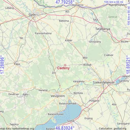
Csetény GPS coordinates[2]
47° 19' 5.016" North, 17° 59' 31.488" East
| Map corner | latitude | longitude |
|---|---|---|
| Upper-left | 47.79258°, | 17.28896° |
| Center: | 47.31806°, | 17.99208° |
| Lower-right: | 46.83924°, | 18.69521° |
| Map W x H: | 106×106 km | = 65.9×65.9mi |
| max Lat: | 48.46667° ⇑55.6% North |
| Csetény: | 47.31806° |
| min Lat: | ⇓44.4% South 45.79108° |
| min Long | Csetény | max Long |
| 16.27358° | 17.99208° | 22.68096° |
| W 14.1%⇐ | ⇒85.9% E |
Elevation
Elevation of Csetény is 290 m = 951 ft, and this is 160.3 m = 526 ft above average elevation for this country.
| Max E: |
444 m = 1457 ft | 1.3% |
| Csetény | 290 m 951 ft | |
| Avg. | 129.7 m = 426 ft | |
Min E: |
71 m = 233 ft | 98.7% |
See also: Hungary elevation on elevation.city.
Geographical zone
Csetény is located in North temperate zone (between Tropic of Cancer and the Arctic Circle). Distance of this North polar circle is 2139.9 km =1329.7 mi to North.| Distance of | km | miles | from Csetény |
|---|---|---|---|
| North Pole | 4745.8 | 2948.9 | to North |
| Arctic Circle | 2139.9 | 1329.7 | to North |
| Tropic Cancer | 2655.4 | 1650 | to South |
| Equator | 5261.3 | 3269.2 | to South |


Nearby cities:
15 places around Csetény: (largest is in red/bold)
• Bakonycsernye
6.3 km =3.9 mi,  84°
84°
• Bakonyszentlászló
16.3 km =10.1 mi,  299°
299°
• Bodajk
18.2 km =11.3 mi,  88°
88°
• Császár
23 km =14.3 mi,  29°
29°
• Fehérvárcsurgó
20.7 km =12.9 mi,  97°
97°
• Hajmáskér
19.3 km =12 mi,  173°
173°
• Kincsesbánya
22.4 km =13.9 mi,  105°
105°
• Kisbér
20.8 km =12.9 mi,  9°
9°
• Litér
24.1 km =15 mi,  177°
177°
• Mór
17.3 km =10.7 mi,  67°
67°
• Pusztavám
21.6 km =13.4 mi,  54°
54°
• Pétfürdő
19.3 km =12 mi,  150°
150°
• Várpalota
17.3 km =10.7 mi,  139°
139°
• Zirc
10.8 km =6.7 mi,  235°
235°
• Ősi
24.1 km =15 mi, 142°
Sources, notices
• [Note1] Compared only with cities in Hungary existing in our database
• [Src1] Map data: © OpenStreetMap contributors (CC-BY-SA)
• [Src2] Other city data from geonames.org with taken over terms of usage.
• [Src3] Geographical zone / Annual Mean Temperature by Robert A. Rohde @ Wikipedia
