Devecser geodata
Devecser (Veszprém) is a seat of a second-order administrative division; located in Hungary in Europe/Budapest (GMT+2) time zone. With population of 5,140 people, there are 292 cities with bigger population in this country. Compared to other cities in Hungary, 65.2% of cities are located further ↑North; 92.2% of cities are located further →East and 85.5% of cities have lower elevation than Devecser. Note1


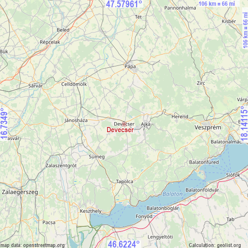
Devecser GPS coordinates[2]
47° 6' 11.376" North, 17° 26' 16.872" East
| Map corner | latitude | longitude |
|---|---|---|
| Upper-left | 47.57961°, | 16.7349° |
| Center: | 47.10316°, | 17.43802° |
| Lower-right: | 46.6224°, | 18.14115° |
| Map W x H: | 106.4×106.4 km | = 66.1×66.1mi |
| max Lat: | 48.46667° ⇑65.2% North |
| Devecser: | 47.10316° |
| min Lat: | ⇓34.8% South 45.79108° |
| min Long | Devecser | max Long |
| 16.27358° | 17.43802° | 22.68096° |
| W 7.8%⇐ | ⇒92.2% E |
Elevation
Elevation of Devecser is 175 m = 574 ft, and this is 45.3 m = 149 ft above average elevation for this country.
| Max E: |
444 m = 1457 ft | 14.5% |
| Devecser | 175 m 574 ft | |
| Avg. | 129.7 m = 426 ft | |
Min E: |
71 m = 233 ft | 85.5% |
See also: Hungary elevation on elevation.city.
Geographical zone
Devecser is located in North temperate zone (between Tropic of Cancer and the Arctic Circle). Distance of this North polar circle is 2163.8 km =1344.5 mi to North.| Distance of | km | miles | from Devecser |
|---|---|---|---|
| North Pole | 4769.7 | 2963.8 | to North |
| Arctic Circle | 2163.8 | 1344.5 | to North |
| Tropic Cancer | 2631.5 | 1635.1 | to South |
| Equator | 5237.4 | 3254.4 | to South |


Nearby cities:
15 places around Devecser: (largest is in red/bold)
• Ajka
9.2 km =5.7 mi,  90°
90°
• Badacsonytomaj
33.4 km =20.8 mi,  170°
170°
• Bánd
26.1 km =16.2 mi, 85°
• Celldömölk
27.7 km =17.2 mi,  308°
308°
• Csabrendek
14.9 km =9.3 mi,  228°
228°
• Herend
23.8 km =14.8 mi,  81°
81°
• Jánosháza
20.7 km =12.9 mi,  274°
274°
• Nemesvámos
33.5 km =20.8 mi,  99°
99°
• Pápa
25.3 km =15.7 mi,  5°
5°
• Sümeg
18.3 km =11.4 mi,  220°
220°
• Tapolca
24.6 km =15.3 mi,  179°
179°
• Türje
28.4 km =17.6 mi,  242°
242°
• Zalaszentgrót
32.4 km =20.1 mi, 237°
• Zánka
31.8 km =19.8 mi,  144°
144°
• Úrkút
15.7 km =9.8 mi, 97°
Sources, notices
• [Note1] Compared only with cities in Hungary existing in our database
• [Src1] Map data: © OpenStreetMap contributors (CC-BY-SA)
• [Src2] Other city data from geonames.org with taken over terms of usage.
• [Src3] Geographical zone / Annual Mean Temperature by Robert A. Rohde @ Wikipedia
