Somogyvár geodata
Somogyvár (Somogy) is a populated place; located in Hungary in Europe/Budapest (GMT+2) time zone. With population of 2,023 people, there are 772 cities with bigger population in this country. Compared to other cities in Hungary, 83.6% of cities are located further ↑North; 89.6% of cities are located further →East and 76.6% of cities have lower elevation than Somogyvár. Note1


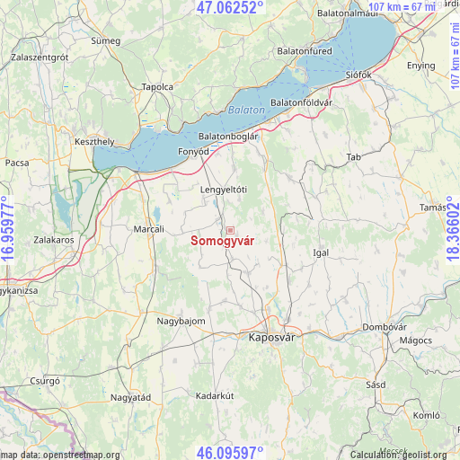
Somogyvár GPS coordinates[2]
46° 34' 53.04" North, 17° 39' 46.404" East
| Map corner | latitude | longitude |
|---|---|---|
| Upper-left | 47.06252°, | 16.95977° |
| Center: | 46.5814°, | 17.66289° |
| Lower-right: | 46.09597°, | 18.36602° |
| Map W x H: | 107.5×107.5 km | = 66.8×66.8mi |
| max Lat: | 48.46667° ⇑83.6% North |
| Somogyvár: | 46.5814° |
| min Lat: | ⇓16.4% South 45.79108° |
| min Long | Somogyvár | max Long |
| 16.27358° | 17.66289° | 22.68096° |
| W 10.4%⇐ | ⇒89.6% E |
Elevation
Elevation of Somogyvár is 150 m = 492 ft, and this is 20.3 m = 67 ft above average elevation for this country.
| Max E: |
444 m = 1457 ft | 23.4% |
| Somogyvár | 150 m 492 ft | |
| Avg. | 129.7 m = 426 ft | |
Min E: |
71 m = 233 ft | 76.6% |
See also: Hungary elevation on elevation.city.
Geographical zone
Somogyvár is located in North temperate zone (between Tropic of Cancer and the Arctic Circle). Distance of this North polar circle is 2221.8 km =1380.6 mi to North.| Distance of | km | miles | from Somogyvár |
|---|---|---|---|
| North Pole | 4827.7 | 2999.8 | to North |
| Arctic Circle | 2221.8 | 1380.6 | to North |
| Tropic Cancer | 2573.4 | 1599 | to South |
| Equator | 5179.4 | 3218.3 | to South |


Nearby cities:
15 places around Somogyvár: (largest is in red/bold)
• Badacsonytomaj
27.6 km =17.1 mi,  335°
335°
• Balatonboglár
21.6 km =13.4 mi,  356°
356°
• Balatonfenyves
19.8 km =12.3 mi,  318°
318°
• Balatonlelle
22.6 km =14 mi,  6°
6°
• Böhönye
28.6 km =17.8 mi,  229°
229°
• Fonyód
20.4 km =12.7 mi, 341°
• Kaposmérő
24.6 km =15.3 mi,  172°
172°
• Kaposvár
26.1 km =16.2 mi,  156°
156°
• Karád
18.3 km =11.4 mi,  48°
48°
• Kéthely
21.8 km =13.5 mi,  289°
289°
• Lengyeltóti
10 km =6.2 mi,  351°
351°
• Marcali
19.2 km =11.9 mi,  271°
271°
• Nagybajom
24 km =14.9 mi,  208°
208°
• Révfülöp
27.4 km =17 mi, 353°
• Taszár
29.6 km =18.4 mi,  141°
141°
Sources, notices
• [Note1] Compared only with cities in Hungary existing in our database
• [Src1] Map data: © OpenStreetMap contributors (CC-BY-SA)
• [Src2] Other city data from geonames.org with taken over terms of usage.
• [Src3] Geographical zone / Annual Mean Temperature by Robert A. Rohde @ Wikipedia
