Kenyam geodata
Kenyam (Papua) is a seat of a second-order administrative division; located in Indonesia in Asia/Jayapura (GMT+9) time zone. In our database, there are 407 cities with bigger population. Compared to other cities in Indonesia, 89% of cities are located further ↓South; 99.6% of cities are located further ←West and 57.3% of cities have lower elevation than Kenyam. Note1


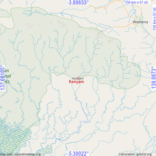
Kenyam GPS coordinates[2]
4° 35' 58.992" South, 138° 23' 3.012" East
| Map corner | latitude | longitude |
|---|---|---|
| Upper-left | -3.89853°, | 137.68105° |
| Center: | -4.59972°, | 138.38417° |
| Lower-right: | -5.30022°, | 139.0873° |
| Map W x H: | 155.9×155.9 km | = 96.9×96.9mi |
| max Lat: | 5.88969° ⇑11% North |
| Kenyam: | -4.59972° |
| min Lat: | ⇓89% South -10.934° |
| min Long | Kenyam | max Long |
| 95.1345° | 138.38417° | 140.9419° |
| W 99.6%⇐ | ⇒0.40000000000001% E |
Elevation
Elevation of Kenyam is 139 m = 456 ft, and this is 90.7 m = 298 ft below average elevation for this country.
| Max E: |
3185 m = 10449 ft | 42.7% |
| Avg. | 229.7 m = 754 ft | |
| Kenyam | 139 m = 456 ft | |
Min E: |
-1 m = -3 ft | 57.3% |
See also: Indonesia elevation on elevation.city.
Geographical zone
Kenyam is located in South Torrid zone (between Equator and Tropic of Capricorn). Distance of Equator is 511.4 km =317.8 mi to North.| Distance of | km | miles | from Kenyam |
|---|---|---|---|
| Equator | 511.4 | 317.8 | to North |
| Tropic Capricorn | 2094.5 | 1301.5 | to South |
| Antarctic Circle | 6889.7 | 4281.1 | to South |
| South Pole | 9495.6 | 5900.3 | to South |


Nearby cities:
15 places around Kenyam: (largest is in red/bold)
• Agats
108.7 km =67.5 mi,  194°
194°
• Beoga
159.3 km =99 mi,  302°
302°
• Bikondini
106.8 km =66.4 mi,  11°
11°
• Dabra
152.3 km =94.6 mi, 8°
• Elelim
174 km =108.1 mi,  57°
57°
• Ilaga
130.9 km =81.3 mi, 303°
• Karubaga
100.4 km =62.4 mi,  4°
4°
• Kobakma
128.5 km =79.8 mi,  35°
35°
• Mapurujaya
172.5 km =107.2 mi,  267°
267°
• Mulia
107.9 km =67 mi,  335°
335°
• Sugapa
176 km =109.4 mi, 302°
• Sumohai
108 km =67.1 mi,  95°
95°
• Tiom
75.6 km =47 mi, 5°
• Wamena
83.7 km =52 mi,  47°
47°
• Wurigelebur
104.3 km =64.8 mi,  26°
26°
Sources, notices
• [Note1] Compared only with cities in Indonesia existing in our database
• [Src1] Map data: © OpenStreetMap contributors (CC-BY-SA)
• [Src2] Other city data from geonames.org with taken over terms of usage.
• [Src3] Geographical zone / Annual Mean Temperature by Robert A. Rohde @ Wikipedia
