Elelim geodata
Elelim (Papua) is a seat of a second-order administrative division; located in Indonesia in Asia/Jayapura (GMT+9) time zone. In our database, there are 407 cities with bigger population. Compared to other cities in Indonesia, 89.8% of cities are located further ↓South; 99.8% of cities are located further ←West and 57.5% of cities have lower elevation than Elelim. Note1


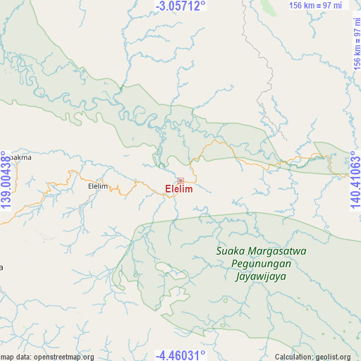
Elelim GPS coordinates[2]
3° 45' 32.4" South, 139° 42' 27" East
| Map corner | latitude | longitude |
|---|---|---|
| Upper-left | -3.05712°, | 139.00438° |
| Center: | -3.759°, | 139.7075° |
| Lower-right: | -4.46031°, | 140.41063° |
| Map W x H: | 156×156 km | = 96.9×96.9mi |
| max Lat: | 5.88969° ⇑10.2% North |
| Elelim: | -3.759° |
| min Lat: | ⇓89.8% South -10.934° |
| min Long | Elelim | max Long |
| 95.1345° | 139.7075° | 140.9419° |
| W 99.8%⇐ | ⇒0.2% E |
Elevation
Elevation of Elelim is 142 m = 466 ft, and this is 87.7 m = 288 ft below average elevation for this country.
| Max E: |
3185 m = 10449 ft | 42.5% |
| Avg. | 229.7 m = 754 ft | |
| Elelim | 142 m = 466 ft | |
Min E: |
-1 m = -3 ft | 57.5% |
See also: Indonesia elevation on elevation.city.
Geographical zone
Elelim is located in South Torrid zone (between Equator and Tropic of Capricorn). Distance of Equator is 418 km =259.7 mi to North.| Distance of | km | miles | from Elelim |
|---|---|---|---|
| Equator | 418 | 259.7 | to North |
| Tropic Capricorn | 2188 | 1359.6 | to South |
| Antarctic Circle | 6983.2 | 4339.2 | to South |
| South Pole | 9589.1 | 5958.4 | to South |


Nearby cities:
15 places around Elelim: (largest is in red/bold)
• Arso
151.2 km =94 mi,  50°
50°
• Bikondini
126.2 km =78.4 mi,  275°
275°
• Dabra
136.8 km =85 mi,  294°
294°
• Genyem
140.1 km =87.1 mi,  20°
20°
• Guay
140.1 km =87.1 mi,  4°
4°
• Karubaga
138.8 km =86.2 mi,  272°
272°
• Kobakma
72.1 km =44.8 mi, 278°
• Sawoi
144.1 km =89.5 mi,  28°
28°
• Sengge
123.4 km =76.7 mi,  73°
73°
• Sumohai
110.6 km =68.7 mi,  200°
200°
• Tiom
140.2 km =87.1 mi,  262°
262°
• Ubrub
130.1 km =80.8 mi,  87°
87°
• Wamena
92.5 km =57.5 mi,  246°
246°
• Waris
148.8 km =92.5 mi,  61°
61°
• Wurigelebur
99.7 km =62 mi, 269°
Sources, notices
• [Note1] Compared only with cities in Indonesia existing in our database
• [Src1] Map data: © OpenStreetMap contributors (CC-BY-SA)
• [Src2] Other city data from geonames.org with taken over terms of usage.
• [Src3] Geographical zone / Annual Mean Temperature by Robert A. Rohde @ Wikipedia
