Soreang geodata
Soreang (West Java) is a seat of a second-order administrative division; located in Indonesia in Asia/Jakarta (GMT+7) time zone. With population of 150,932 people, there are 74 cities with bigger population in this country. Compared to other cities in Indonesia, 63.8% of cities are located further ↓South; 84% of cities are located further →East and 93.4% of cities have lower elevation than Soreang. Note1


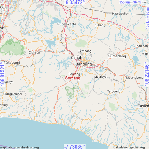
Soreang GPS coordinates[2]
7° 1' 59.016" South, 107° 31' 5.988" East
| Map corner | latitude | longitude |
|---|---|---|
| Upper-left | -6.33472°, | 106.81521° |
| Center: | -7.03306°, | 107.51833° |
| Lower-right: | -7.73035°, | 108.22146° |
| Map W x H: | 155.2×155.2 km | = 96.4×96.4mi |
| max Lat: | 5.88969° ⇑36.2% North |
| Soreang: | -7.03306° |
| min Lat: | ⇓63.8% South -10.934° |
| min Long | Soreang | max Long |
| 95.1345° | 107.51833° | 140.9419° |
| W 16%⇐ | ⇒84% E |
Elevation
Elevation of Soreang is 744 m = 2441 ft, and this is 514.3 m = 1687 ft above average elevation for this country.
| Max E: |
3185 m = 10449 ft | 6.6% |
| Soreang | 744 m 2441 ft | |
| Avg. | 229.7 m = 754 ft | |
Min E: |
-1 m = -3 ft | 93.4% |
See also: Soreang elevation on elevation.city.
Geographical zone
Soreang is located in South Torrid zone (between Equator and Tropic of Capricorn). Distance of Equator is 782 km =485.9 mi to North.| Distance of | km | miles | from Soreang |
|---|---|---|---|
| Equator | 782 | 485.9 | to North |
| Tropic Capricorn | 1823.9 | 1133.3 | to South |
| Antarctic Circle | 6619.2 | 4113 | to South |
| South Pole | 9225.1 | 5732.2 | to South |


Nearby cities:
15 places around Soreang: (largest is in red/bold)
• Bandung
15.7 km =9.8 mi,  38°
38°
• Banjar
20.5 km =12.7 mi,  207°
207°
• Banjaran
7.8 km =4.8 mi,  100°
100°
• Cibungur
28.8 km =17.9 mi,  176°
176°
• Cileunyi
27.9 km =17.3 mi,  67°
67°
• Cimahi
18.1 km =11.2 mi,  8°
8°
• Lembang
26.9 km =16.7 mi,  23°
23°
• Margahayukencana
8.8 km =5.5 mi, 38°
• Padalarang
22.3 km =13.9 mi,  346°
346°
• Pameungpeuk
9.6 km =6 mi,  80°
80°
• Paseh
28.2 km =17.5 mi,  105°
105°
• Pasirangin Satu
27.7 km =17.2 mi,  173°
173°
• Santosa
27.9 km =17.3 mi,  151°
151°
• Sawahlegok
29 km =18 mi,  191°
191°
• Talegong Dua
29.7 km =18.5 mi, 181°
Sources, notices
• [Note1] Compared only with cities in Indonesia existing in our database
• [Src1] Map data: © OpenStreetMap contributors (CC-BY-SA)
• [Src2] Other city data from geonames.org with taken over terms of usage.
• [Src3] Geographical zone / Annual Mean Temperature by Robert A. Rohde @ Wikipedia
