Bandung geodata
Bandung (West Java) is a seat of a first-order administrative division; located in Indonesia in Asia/Jakarta (GMT+7) time zone. With population of 1,699,719 people, there are 3 cities with bigger population in this country. Compared to other cities in Indonesia, 71.1% of cities are located further ↓South; 83.8% of cities are located further →East and 92.1% of cities have lower elevation than Bandung. Note1


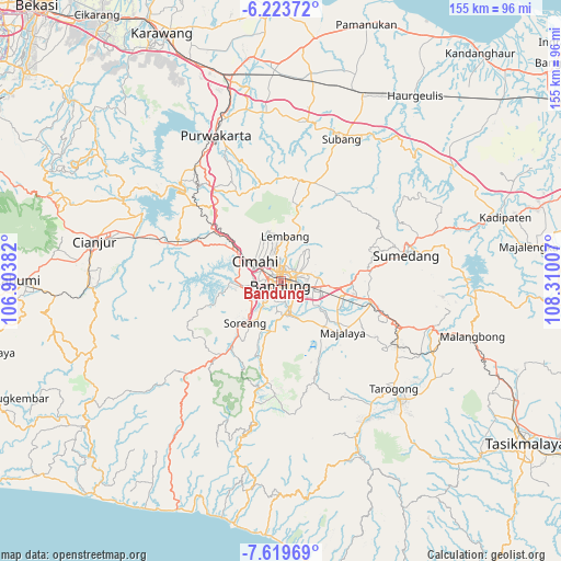
Bandung GPS coordinates[2]
6° 55' 19.992" South, 107° 36' 24.984" East
| Map corner | latitude | longitude |
|---|---|---|
| Upper-left | -6.22372°, | 106.90382° |
| Center: | -6.92222°, | 107.60694° |
| Lower-right: | -7.61969°, | 108.31007° |
| Map W x H: | 155.2×155.2 km | = 96.4×96.4mi |
| max Lat: | 5.88969° ⇑28.9% North |
| Bandung: | -6.92222° |
| min Lat: | ⇓71.1% South -10.934° |
| min Long | Bandung | max Long |
| 95.1345° | 107.60694° | 140.9419° |
| W 16.2%⇐ | ⇒83.8% E |
Elevation
Elevation of Bandung is 714 m = 2343 ft, and this is 484.3 m = 1589 ft above average elevation for this country.
| Max E: |
3185 m = 10449 ft | 7.9% |
| Bandung | 714 m 2343 ft | |
| Avg. | 229.7 m = 754 ft | |
Min E: |
-1 m = -3 ft | 92.1% |
See also: Bandung elevation on elevation.city.
Geographical zone
Bandung is located in South Torrid zone (between Equator and Tropic of Capricorn). Distance of Equator is 769.7 km =478.3 mi to North.| Distance of | km | miles | from Bandung |
|---|---|---|---|
| Equator | 769.7 | 478.3 | to North |
| Tropic Capricorn | 1836.2 | 1141 | to South |
| Antarctic Circle | 6631.5 | 4120.6 | to South |
| South Pole | 9237.4 | 5739.9 | to South |


Nearby cities:
15 places around Bandung: (largest is in red/bold)
• Banjaran
13.8 km =8.6 mi,  188°
188°
• Cigorowong Kidul
32.6 km =20.3 mi,  109°
109°
• Ciharus
35.6 km =22.1 mi,  123°
123°
• Cileunyi
16.2 km =10.1 mi,  96°
96°
• Cimahi
9 km =5.6 mi,  308°
308°
• Lembang
12.3 km =7.6 mi,  5°
5°
• Margabakti
31.5 km =19.6 mi, 108°
• Margahayukencana
6.9 km =4.3 mi,  218°
218°
• Maribaya
34.9 km =21.7 mi, 121°
• Padalarang
17.5 km =10.9 mi,  302°
302°
• Pameungpeuk
10.7 km =6.6 mi,  181°
181°
• Paseh
26.5 km =16.5 mi,  139°
139°
• Soreang
15.7 km =9.8 mi, 218°
• Sumedang
34.9 km =21.7 mi,  78°
78°
• Sumedang Utara
35.1 km =21.8 mi, 76°
Sources, notices
• [Note1] Compared only with cities in Indonesia existing in our database
• [Src1] Map data: © OpenStreetMap contributors (CC-BY-SA)
• [Src2] Other city data from geonames.org with taken over terms of usage.
• [Src3] Geographical zone / Annual Mean Temperature by Robert A. Rohde @ Wikipedia
