Pameungpeuk geodata
Pameungpeuk (West Java) is a populated place; located in Indonesia in Asia/Jakarta (GMT+7) time zone. With population of 48,294 people, there are 240 cities with bigger population in this country. Compared to other cities in Indonesia, 64.7% of cities are located further ↓South; 83.8% of cities are located further →East and 90.7% of cities have lower elevation than Pameungpeuk. Note1


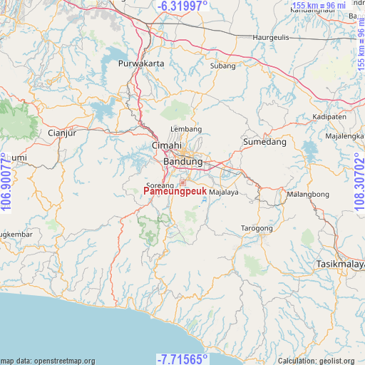
Pameungpeuk GPS coordinates[2]
7° 1' 5.988" South, 107° 36' 14.004" East
| Map corner | latitude | longitude |
|---|---|---|
| Upper-left | -6.31997°, | 106.90077° |
| Center: | -7.01833°, | 107.60389° |
| Lower-right: | -7.71565°, | 108.30702° |
| Map W x H: | 155.2×155.2 km | = 96.4×96.4mi |
| max Lat: | 5.88969° ⇑35.3% North |
| Pameungpeuk: | -7.01833° |
| min Lat: | ⇓64.7% South -10.934° |
| min Long | Pameungpeuk | max Long |
| 95.1345° | 107.60389° | 140.9419° |
| W 16.2%⇐ | ⇒83.8% E |
Elevation
Elevation of Pameungpeuk is 665 m = 2182 ft, and this is 435.3 m = 1428 ft above average elevation for this country.
| Max E: |
3185 m = 10449 ft | 9.3% |
| Pameungpeuk | 665 m 2182 ft | |
| Avg. | 229.7 m = 754 ft | |
Min E: |
-1 m = -3 ft | 90.7% |
See also: Pameungpeuk elevation on elevation.city.
Geographical zone
Pameungpeuk is located in South Torrid zone (between Equator and Tropic of Capricorn). Distance of Equator is 780.4 km =484.9 mi to North.| Distance of | km | miles | from Pameungpeuk |
|---|---|---|---|
| Equator | 780.4 | 484.9 | to North |
| Tropic Capricorn | 1825.6 | 1134.4 | to South |
| Antarctic Circle | 6620.8 | 4114 | to South |
| South Pole | 9226.7 | 5733.2 | to South |


Nearby cities:
15 places around Pameungpeuk: (largest is in red/bold)
• Bandung
10.7 km =6.6 mi,  1°
1°
• Banjar
27.4 km =17 mi,  224°
224°
• Banjaran
3.5 km =2.2 mi,  210°
210°
• Cigorowong Kidul
31 km =19.3 mi,  90°
90°
• Cileunyi
18.7 km =11.6 mi,  61°
61°
• Cimahi
17.6 km =10.9 mi,  337°
337°
• Lembang
23 km =14.3 mi, 3°
• Margabakti
30.2 km =18.8 mi, 89°
• Margahayukencana
6.6 km =4.1 mi,  322°
322°
• Negla
29.4 km =18.3 mi,  164°
164°
• Padalarang
24.7 km =15.3 mi, 324°
• Paseh
20 km =12.4 mi,  117°
117°
• Pasirangin Satu
29.7 km =18.5 mi,  191°
191°
• Santosa
26.5 km =16.5 mi,  171°
171°
• Soreang
9.6 km =6 mi,  260°
260°
Sources, notices
• [Note1] Compared only with cities in Indonesia existing in our database
• [Src1] Map data: © OpenStreetMap contributors (CC-BY-SA)
• [Src2] Other city data from geonames.org with taken over terms of usage.
• [Src3] Geographical zone / Annual Mean Temperature by Robert A. Rohde @ Wikipedia
