Lembang geodata
Lembang (West Java) is a populated place; located in Indonesia in Asia/Jakarta (GMT+7) time zone. With population of 183,130 people, there are 61 cities with bigger population in this country. Compared to other cities in Indonesia, 75.9% of cities are located further ↓South; 83.7% of cities are located further →East and 99.2% of cities have lower elevation than Lembang. Note1


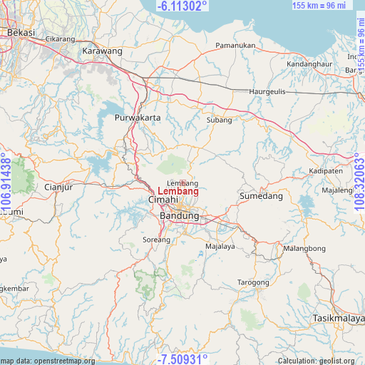
Lembang GPS coordinates[2]
6° 48' 42.012" South, 107° 37' 3" East
| Map corner | latitude | longitude |
|---|---|---|
| Upper-left | -6.11302°, | 106.91438° |
| Center: | -6.81167°, | 107.6175° |
| Lower-right: | -7.50931°, | 108.32063° |
| Map W x H: | 155.3×155.3 km | = 96.5×96.5mi |
| max Lat: | 5.88969° ⇑24.1% North |
| Lembang: | -6.81167° |
| min Lat: | ⇓75.9% South -10.934° |
| min Long | Lembang | max Long |
| 95.1345° | 107.6175° | 140.9419° |
| W 16.3%⇐ | ⇒83.7% E |
Elevation
Elevation of Lembang is 1252 m = 4108 ft, and this is 1022.3 m = 3354 ft above average elevation for this country.
| Max E: |
3185 m = 10449 ft | 0.8% |
| Lembang | 1252 m 4108 ft | |
| Avg. | 229.7 m = 754 ft | |
Min E: |
-1 m = -3 ft | 99.2% |
See also: Lembang elevation on elevation.city.
Geographical zone
Lembang is located in South Torrid zone (between Equator and Tropic of Capricorn). Distance of Equator is 757.4 km =470.6 mi to North.| Distance of | km | miles | from Lembang |
|---|---|---|---|
| Equator | 757.4 | 470.6 | to North |
| Tropic Capricorn | 1848.5 | 1148.6 | to South |
| Antarctic Circle | 6643.8 | 4128.3 | to South |
| South Pole | 9249.7 | 5747.5 | to South |


Nearby cities:
15 places around Lembang: (largest is in red/bold)
• Bandung
12.3 km =7.6 mi,  185°
185°
• Banjaran
26.2 km =16.3 mi, 187°
• Cigorowong Kidul
37.6 km =23.4 mi,  128°
128°
• Cileunyi
20.6 km =12.8 mi, 133°
• Cimahi
10.7 km =6.6 mi,  230°
230°
• Margabakti
36.4 km =22.6 mi, 128°
• Margahayukencana
18.5 km =11.5 mi,  197°
197°
• Padalarang
16.2 km =10.1 mi,  259°
259°
• Pameungpeuk
23 km =14.3 mi,  183°
183°
• Paseh
36.2 km =22.5 mi,  153°
153°
• Purwakarta
34.2 km =21.3 mi,  325°
325°
• Soreang
26.9 km =16.7 mi, 203°
• Subang
31 km =19.3 mi,  29°
29°
• Sumedang
33.4 km =20.8 mi,  98°
98°
• Sumedang Utara
33.3 km =20.7 mi, 97°
Sources, notices
• [Note1] Compared only with cities in Indonesia existing in our database
• [Src1] Map data: © OpenStreetMap contributors (CC-BY-SA)
• [Src2] Other city data from geonames.org with taken over terms of usage.
• [Src3] Geographical zone / Annual Mean Temperature by Robert A. Rohde @ Wikipedia
