Banjaran geodata
Banjaran (West Java) is a populated place; located in Indonesia in Asia/Jakarta (GMT+7) time zone. With population of 164,952 people, there are 67 cities with bigger population in this country. Compared to other cities in Indonesia, 62.9% of cities are located further ↓South; 83.8% of cities are located further →East and 90.9% of cities have lower elevation than Banjaran. Note1


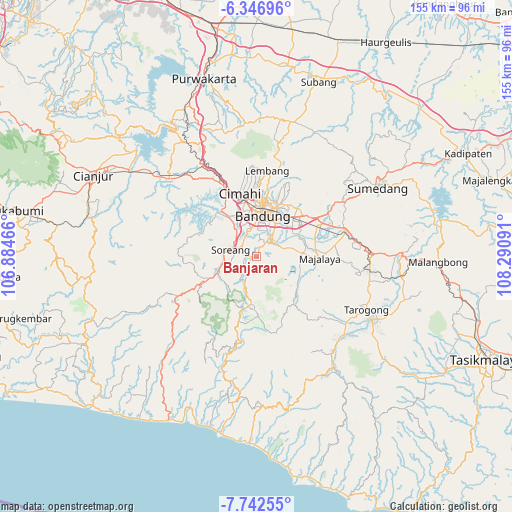
Banjaran GPS coordinates[2]
7° 2' 43.008" South, 107° 35' 16.008" East
| Map corner | latitude | longitude |
|---|---|---|
| Upper-left | -6.34696°, | 106.88466° |
| Center: | -7.04528°, | 107.58778° |
| Lower-right: | -7.74255°, | 108.29091° |
| Map W x H: | 155.2×155.2 km | = 96.4×96.4mi |
| max Lat: | 5.88969° ⇑37.1% North |
| Banjaran: | -7.04528° |
| min Lat: | ⇓62.9% South -10.934° |
| min Long | Banjaran | max Long |
| 95.1345° | 107.58778° | 140.9419° |
| W 16.2%⇐ | ⇒83.8% E |
Elevation
Elevation of Banjaran is 674 m = 2211 ft, and this is 444.3 m = 1458 ft above average elevation for this country.
| Max E: |
3185 m = 10449 ft | 9.1% |
| Banjaran | 674 m 2211 ft | |
| Avg. | 229.7 m = 754 ft | |
Min E: |
-1 m = -3 ft | 90.9% |
See also: Banjaran elevation on elevation.city.
Geographical zone
Banjaran is located in South Torrid zone (between Equator and Tropic of Capricorn). Distance of Equator is 783.4 km =486.8 mi to North.| Distance of | km | miles | from Banjaran |
|---|---|---|---|
| Equator | 783.4 | 486.8 | to North |
| Tropic Capricorn | 1822.6 | 1132.5 | to South |
| Antarctic Circle | 6617.8 | 4112.1 | to South |
| South Pole | 9223.7 | 5731.3 | to South |


Nearby cities:
15 places around Banjaran: (largest is in red/bold)
• Bandung
13.8 km =8.6 mi,  8°
8°
• Banjar
24 km =14.9 mi,  225°
225°
• Cibungur
28 km =17.4 mi,  192°
192°
• Cileunyi
21.7 km =13.5 mi,  56°
56°
• Cimahi
19.9 km =12.4 mi,  345°
345°
• Lembang
26.2 km =16.3 mi, 7°
• Margahayukencana
8.6 km =5.3 mi,  344°
344°
• Negla
27.1 km =16.8 mi,  159°
159°
• Padalarang
26.3 km =16.3 mi,  331°
331°
• Pameungpeuk
3.5 km =2.2 mi,  30°
30°
• Paseh
20.5 km =12.7 mi,  108°
108°
• Pasirangin Satu
26.5 km =16.5 mi, 189°
• Santosa
23.8 km =14.8 mi,  166°
166°
• Soreang
7.8 km =4.8 mi,  280°
280°
• Talegong Dua
29.5 km =18.3 mi,  196°
196°
Sources, notices
• [Note1] Compared only with cities in Indonesia existing in our database
• [Src1] Map data: © OpenStreetMap contributors (CC-BY-SA)
• [Src2] Other city data from geonames.org with taken over terms of usage.
• [Src3] Geographical zone / Annual Mean Temperature by Robert A. Rohde @ Wikipedia
