Salatiga geodata
Salatiga (Central Java) is a populated place; located in Indonesia in Asia/Jakarta (GMT+7) time zone. With population of 172,645 people, there are 65 cities with bigger population in this country. Compared to other cities in Indonesia, 50.3% of cities are located further ↑North; 65.4% of cities are located further →East and 87.6% of cities have lower elevation than Salatiga. Note1


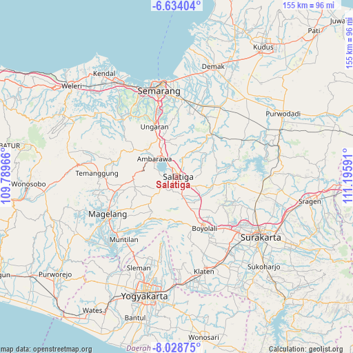
Salatiga GPS coordinates[2]
7° 19' 54.984" South, 110° 29' 34.008" East
| Map corner | latitude | longitude |
|---|---|---|
| Upper-left | -6.63404°, | 109.78966° |
| Center: | -7.33194°, | 110.49278° |
| Lower-right: | -8.02875°, | 111.19591° |
| Map W x H: | 155.1×155.1 km | = 96.4×96.4mi |
| max Lat: | 5.88969° ⇑50.3% North |
| Salatiga: | -7.33194° |
| min Lat: | ⇓49.7% South -10.934° |
| min Long | Salatiga | max Long |
| 95.1345° | 110.49278° | 140.9419° |
| W 34.6%⇐ | ⇒65.4% E |
Elevation
Elevation of Salatiga is 571 m = 1873 ft, and this is 341.3 m = 1120 ft above average elevation for this country.
| Max E: |
3185 m = 10449 ft | 12.4% |
| Salatiga | 571 m 1873 ft | |
| Avg. | 229.7 m = 754 ft | |
Min E: |
-1 m = -3 ft | 87.6% |
See also: Salatiga elevation on elevation.city.
Geographical zone
Salatiga is located in South Torrid zone (between Equator and Tropic of Capricorn). Distance of Equator is 815.2 km =506.5 mi to North.| Distance of | km | miles | from Salatiga |
|---|---|---|---|
| Equator | 815.2 | 506.5 | to North |
| Tropic Capricorn | 1790.7 | 1112.7 | to South |
| Antarctic Circle | 6585.9 | 4092.3 | to South |
| South Pole | 9191.8 | 5711.5 | to South |


Nearby cities:
15 places around Salatiga: (largest is in red/bold)
• Ambarawa
13 km =8.1 mi,  305°
305°
• Boyolali
25.1 km =15.6 mi,  153°
153°
• Colomadu
36.1 km =22.4 mi,  128°
128°
• Delanggu
38 km =23.6 mi, 146°
• Gatak
37.1 km =23.1 mi,  140°
140°
• Gunung Kendil
9.8 km =6.1 mi,  270°
270°
• Karanganom
38.1 km =23.7 mi,  157°
157°
• Kartasura
36.4 km =22.6 mi, 132°
• Magelang
34 km =21.1 mi,  243°
243°
• Mertoyudan
36.1 km =22.4 mi,  234°
234°
• Mranggen
34 km =21.1 mi,  4°
4°
• Muntilan
35.4 km =22 mi,  218°
218°
• Ngemplak
34.6 km =21.5 mi, 134°
• Temanggung
33.1 km =20.6 mi, 272°
• Ungaran
23.5 km =14.6 mi,  335°
335°
Sources, notices
• [Note1] Compared only with cities in Indonesia existing in our database
• [Src1] Map data: © OpenStreetMap contributors (CC-BY-SA)
• [Src2] Other city data from geonames.org with taken over terms of usage.
• [Src3] Geographical zone / Annual Mean Temperature by Robert A. Rohde @ Wikipedia
