Ambarawa geodata
Ambarawa (Central Java) is a populated place; located in Indonesia in Asia/Jakarta (GMT+7) time zone. With population of 84,379 people, there are 155 cities with bigger population in this country. Compared to other cities in Indonesia, 52.5% of cities are located further ↓South; 65.5% of cities are located further →East and 83.1% of cities have lower elevation than Ambarawa. Note1


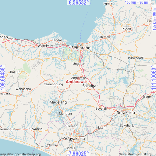
Ambarawa GPS coordinates[2]
7° 15' 47.988" South, 110° 23' 51" East
| Map corner | latitude | longitude |
|---|---|---|
| Upper-left | -6.56532°, | 109.69438° |
| Center: | -7.26333°, | 110.3975° |
| Lower-right: | -7.96025°, | 111.10063° |
| Map W x H: | 155.1×155.1 km | = 96.4×96.4mi |
| max Lat: | 5.88969° ⇑47.5% North |
| Ambarawa: | -7.26333° |
| min Lat: | ⇓52.5% South -10.934° |
| min Long | Ambarawa | max Long |
| 95.1345° | 110.3975° | 140.9419° |
| W 34.5%⇐ | ⇒65.5% E |
Elevation
Elevation of Ambarawa is 481 m = 1578 ft, and this is 251.3 m = 824 ft above average elevation for this country.
| Max E: |
3185 m = 10449 ft | 16.9% |
| Ambarawa | 481 m 1578 ft | |
| Avg. | 229.7 m = 754 ft | |
Min E: |
-1 m = -3 ft | 83.1% |
See also: Ambarawa elevation on elevation.city.
Geographical zone
Ambarawa is located in South Torrid zone (between Equator and Tropic of Capricorn). Distance of Equator is 807.6 km =501.8 mi to North.| Distance of | km | miles | from Ambarawa |
|---|---|---|---|
| Equator | 807.6 | 501.8 | to North |
| Tropic Capricorn | 1798.3 | 1117.4 | to South |
| Antarctic Circle | 6593.6 | 4097.1 | to South |
| South Pole | 9199.5 | 5716.3 | to South |


Nearby cities:
15 places around Ambarawa: (largest is in red/bold)
• Boyolali
37.1 km =23.1 mi,  143°
143°
• Colomadu
49.1 km =30.5 mi,  127°
127°
• Gunung Kendil
7.6 km =4.7 mi,  174°
174°
• Kendal
43.7 km =27.2 mi,  330°
330°
• Magelang
30.4 km =18.9 mi,  220°
220°
• Mertoyudan
34.2 km =21.3 mi,  213°
213°
• Mranggen
29.4 km =18.3 mi,  26°
26°
• Mungkid
41.6 km =25.8 mi, 208°
• Muntilan
37.2 km =23.1 mi,  198°
198°
• Ngemplak
47.4 km =29.5 mi, 132°
• Salatiga
13 km =8.1 mi, 125°
• Semarang
30.2 km =18.8 mi,  4°
4°
• Temanggung
23.4 km =14.5 mi,  254°
254°
• Ungaran
13.8 km =8.6 mi, 3°
• Weleri
48.9 km =30.4 mi,  311°
311°
Sources, notices
• [Note1] Compared only with cities in Indonesia existing in our database
• [Src1] Map data: © OpenStreetMap contributors (CC-BY-SA)
• [Src2] Other city data from geonames.org with taken over terms of usage.
• [Src3] Geographical zone / Annual Mean Temperature by Robert A. Rohde @ Wikipedia
