Rengasdengklok geodata
Rengasdengklok (West Java) is a populated place; located in Indonesia in Asia/Jakarta (GMT+7) time zone. With population of 201,463 people, there are 51 cities with bigger population in this country. Compared to other cities in Indonesia, 87.7% of cities are located further ↓South; 84.4% of cities are located further →East and 90.6% of cities have higher elevation than Rengasdengklok. Note1


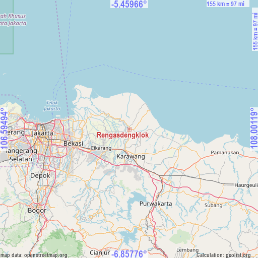
Rengasdengklok GPS coordinates[2]
6° 9' 33.012" South, 107° 17' 53.016" East
| Map corner | latitude | longitude |
|---|---|---|
| Upper-left | -5.45966°, | 106.59494° |
| Center: | -6.15917°, | 107.29806° |
| Lower-right: | -6.85776°, | 108.00119° |
| Map W x H: | 155.5×155.5 km | = 96.6×96.6mi |
| max Lat: | 5.88969° ⇑12.3% North |
| Rengasdengklok: | -6.15917° |
| min Lat: | ⇓87.7% South -10.934° |
| min Long | Rengasdengklok | max Long |
| 95.1345° | 107.29806° | 140.9419° |
| W 15.6%⇐ | ⇒84.4% E |
Elevation
Elevation of Rengasdengklok is 10 m = 33 ft, and this is 219.7 m = 721 ft below average elevation for this country.
| Max E: |
3185 m = 10449 ft | 90.6% |
| Avg. | 229.7 m = 754 ft | |
| Rengasdengklok | 10 m = 33 ft | |
Min E: |
-1 m = -3 ft | 9.4% |
See also: Rengasdengklok elevation on elevation.city.
Geographical zone
Rengasdengklok is located in South Torrid zone (between Equator and Tropic of Capricorn). Distance of Equator is 684.8 km =425.5 mi to North.| Distance of | km | miles | from Rengasdengklok |
|---|---|---|---|
| Equator | 684.8 | 425.5 | to North |
| Tropic Capricorn | 1921.1 | 1193.7 | to South |
| Antarctic Circle | 6716.3 | 4173.3 | to South |
| South Pole | 9322.2 | 5792.5 | to South |


Nearby cities:
15 places around Rengasdengklok: (largest is in red/bold)
• Bekasi
35.1 km =21.8 mi,  256°
256°
• Cibinong
60.8 km =37.8 mi,  233°
233°
• Cikampek
33.8 km =21 mi,  148°
148°
• Cikarang
19.7 km =12.2 mi, 234°
• Cileungsir
45.7 km =28.4 mi,  235°
235°
• Ciputat
67.2 km =41.8 mi, 262°
• Citeureup
58.6 km =36.4 mi, 231°
• Depok
59.4 km =36.9 mi, 243°
• Jakarta
50.4 km =31.3 mi, 262°
• Karawang
16.1 km =10 mi,  177°
177°
• Pamanukan
58.3 km =36.2 mi,  103°
103°
• Pamulang
65.1 km =40.5 mi,  251°
251°
• Purwakarta
47.1 km =29.3 mi,  160°
160°
• Sawangan
63.9 km =39.7 mi, 244°
• South Tangerang
65.7 km =40.8 mi, 257°
Sources, notices
• [Note1] Compared only with cities in Indonesia existing in our database
• [Src1] Map data: © OpenStreetMap contributors (CC-BY-SA)
• [Src2] Other city data from geonames.org with taken over terms of usage.
• [Src3] Geographical zone / Annual Mean Temperature by Robert A. Rohde @ Wikipedia
