South Tangerang geodata
South Tangerang (Banten) is a populated place; located in Indonesia in Asia/Jakarta (GMT+7) time zone. With population of 1,303,569 people, there are 8 cities with bigger population in this country. Compared to other cities in Indonesia, 86.9% of cities are located further ↓South; 86.6% of cities are located further →East and 66.4% of cities have higher elevation than South Tangerang. Note1


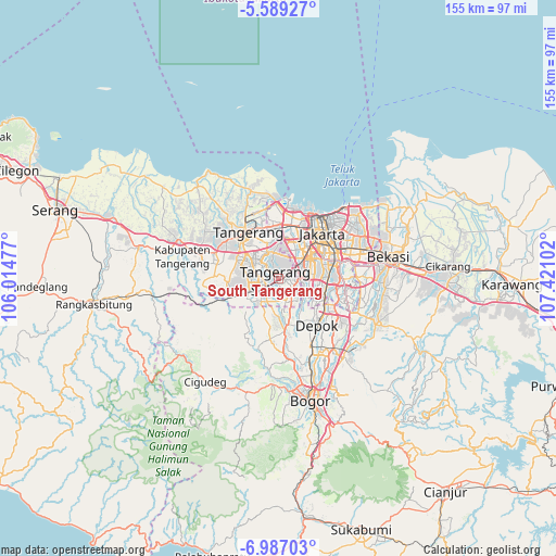
South Tangerang GPS coordinates[2]
6° 17' 19.032" South, 106° 43' 4.404" East
| Map corner | latitude | longitude |
|---|---|---|
| Upper-left | -5.58927°, | 106.01477° |
| Center: | -6.28862°, | 106.71789° |
| Lower-right: | -6.98703°, | 107.42102° |
| Map W x H: | 155.4×155.4 km | = 96.6×96.6mi |
| max Lat: | 5.88969° ⇑13.1% North |
| South Tangerang: | -6.28862° |
| min Lat: | ⇓86.9% South -10.934° |
| min Long | South Tangerang | max Long |
| 95.1345° | 106.71789° | 140.9419° |
| W 13.4%⇐ | ⇒86.6% E |
Elevation
Elevation of South Tangerang is 39 m = 128 ft, and this is 190.7 m = 626 ft below average elevation for this country.
| Max E: |
3185 m = 10449 ft | 66.4% |
| Avg. | 229.7 m = 754 ft | |
| South Tangerang | 39 m = 128 ft | |
Min E: |
-1 m = -3 ft | 33.6% |
See also: South Tangerang elevation on elevation.city.
Geographical zone
South Tangerang is located in South Torrid zone (between Equator and Tropic of Capricorn). Distance of Equator is 699.2 km =434.5 mi to North.| Distance of | km | miles | from South Tangerang |
|---|---|---|---|
| Equator | 699.2 | 434.5 | to North |
| Tropic Capricorn | 1906.7 | 1184.8 | to South |
| Antarctic Circle | 6701.9 | 4164.4 | to South |
| South Pole | 9307.8 | 5783.6 | to South |


Nearby cities:
15 places around South Tangerang: (largest is in red/bold)
• Cibinong
26.2 km =16.3 mi,  144°
144°
• Cikupa
23.9 km =14.9 mi,  284°
284°
• Ciputat
6.2 km =3.9 mi,  336°
336°
• Curug
18 km =11.2 mi, 278°
• Depok
16.7 km =10.4 mi, 138°
• Jakarta
16.3 km =10.1 mi,  59°
59°
• Pamulang
6.4 km =4 mi,  159°
159°
• Parung
14.9 km =9.3 mi,  173°
173°
• Pasarkemis
24.6 km =15.3 mi,  302°
302°
• Sawangan
14.1 km =8.8 mi,  153°
153°
• Sepatan
24.6 km =15.3 mi,  320°
320°
• Serpong
6.7 km =4.2 mi,  242°
242°
• Tangerang
15.7 km =9.8 mi, 321°
• Teluknaga
22.9 km =14.2 mi, 337°
• Tigaraksa
23.5 km =14.6 mi,  286°
286°
Sources, notices
• [Note1] Compared only with cities in Indonesia existing in our database
• [Src1] Map data: © OpenStreetMap contributors (CC-BY-SA)
• [Src2] Other city data from geonames.org with taken over terms of usage.
• [Src3] Geographical zone / Annual Mean Temperature by Robert A. Rohde @ Wikipedia
