Bekasi geodata
Bekasi (West Java) is a populated place; located in Indonesia in Asia/Jakarta (GMT+7) time zone. With population of 1,520,119 people, there are 4 cities with bigger population in this country. Compared to other cities in Indonesia, 87.2% of cities are located further ↓South; 85.5% of cities are located further →East and 80.9% of cities have higher elevation than Bekasi. Note1


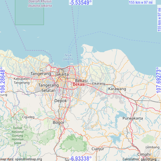
Bekasi GPS coordinates[2]
6° 14' 5.64" South, 106° 59' 22.56" East
| Map corner | latitude | longitude |
|---|---|---|
| Upper-left | -5.53549°, | 106.28648° |
| Center: | -6.2349°, | 106.9896° |
| Lower-right: | -6.93338°, | 107.69273° |
| Map W x H: | 155.4×155.4 km | = 96.6×96.6mi |
| max Lat: | 5.88969° ⇑12.8% North |
| Bekasi: | -6.2349° |
| min Lat: | ⇓87.2% South -10.934° |
| min Long | Bekasi | max Long |
| 95.1345° | 106.9896° | 140.9419° |
| W 14.5%⇐ | ⇒85.5% E |
Elevation
Elevation of Bekasi is 18 m = 59 ft, and this is 211.7 m = 695 ft below average elevation for this country.
| Max E: |
3185 m = 10449 ft | 80.9% |
| Avg. | 229.7 m = 754 ft | |
| Bekasi | 18 m = 59 ft | |
Min E: |
-1 m = -3 ft | 19.1% |
See also: Bekasi elevation on elevation.city.
Geographical zone
Bekasi is located in South Torrid zone (between Equator and Tropic of Capricorn). Distance of Equator is 693.3 km =430.8 mi to North.| Distance of | km | miles | from Bekasi |
|---|---|---|---|
| Equator | 693.3 | 430.8 | to North |
| Tropic Capricorn | 1912.7 | 1188.5 | to South |
| Antarctic Circle | 6707.9 | 4168.1 | to South |
| South Pole | 9313.8 | 5787.3 | to South |


Nearby cities:
15 places around Bekasi: (largest is in red/bold)
• Cibinong
31.3 km =19.4 mi,  208°
208°
• Cikarang
18.3 km =11.4 mi,  99°
99°
• Cileungsir
18.1 km =11.2 mi,  190°
190°
• Ciputat
32.5 km =20.2 mi,  269°
269°
• Citeureup
30.3 km =18.8 mi,  203°
203°
• Depok
26.3 km =16.3 mi,  225°
225°
• Jakarta
16.1 km =10 mi,  278°
278°
• Karawang
35.7 km =22.2 mi, 102°
• Pamulang
30.3 km =18.8 mi,  246°
246°
• Parung
35.1 km =21.8 mi, 233°
• Rengasdengklok
35.1 km =21.8 mi,  76°
76°
• Sawangan
30.2 km =18.8 mi, 231°
• Serpong
37.1 km =23.1 mi,  255°
255°
• South Tangerang
30.6 km =19 mi, 258°
• Tangerang
40.2 km =25 mi, 279°
Sources, notices
• [Note1] Compared only with cities in Indonesia existing in our database
• [Src1] Map data: © OpenStreetMap contributors (CC-BY-SA)
• [Src2] Other city data from geonames.org with taken over terms of usage.
• [Src3] Geographical zone / Annual Mean Temperature by Robert A. Rohde @ Wikipedia
