Jakarta geodata
Jakarta is a capital of a political entity; located in Indonesia in Asia/Jakarta (GMT+7) time zone. With population of 8,540,121 people, there are 0 cities with bigger population in this country. Compared to other cities in Indonesia, 87.4% of cities are located further ↓South; 86.1% of cities are located further →East and 83% of cities have higher elevation than Jakarta. Note1


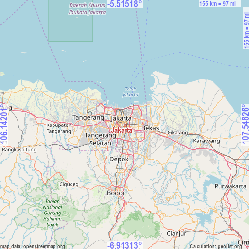
Jakarta GPS coordinates[2]
6° 12' 52.632" South, 106° 50' 42.468" East
| Map corner | latitude | longitude |
|---|---|---|
| Upper-left | -5.51518°, | 106.14201° |
| Center: | -6.21462°, | 106.84513° |
| Lower-right: | -6.91313°, | 107.54826° |
| Map W x H: | 155.4×155.4 km | = 96.6×96.6mi |
| max Lat: | 5.88969° ⇑12.6% North |
| Jakarta: | -6.21462° |
| min Lat: | ⇓87.4% South -10.934° |
| min Long | Jakarta | max Long |
| 95.1345° | 106.84513° | 140.9419° |
| W 13.9%⇐ | ⇒86.1% E |
Elevation
Elevation of Jakarta is 16 m = 52 ft, and this is 213.7 m = 701 ft below average elevation for this country.
| Max E: |
3185 m = 10449 ft | 83% |
| Avg. | 229.7 m = 754 ft | |
| Jakarta | 16 m = 52 ft | |
Min E: |
-1 m = -3 ft | 17% |
See also: Jakarta elevation on elevation.city.
Geographical zone
Jakarta is located in South Torrid zone (between Equator and Tropic of Capricorn). Distance of Equator is 691 km =429.4 mi to North.| Distance of | km | miles | from Jakarta |
|---|---|---|---|
| Equator | 691 | 429.4 | to North |
| Tropic Capricorn | 1914.9 | 1189.9 | to South |
| Antarctic Circle | 6710.2 | 4169.5 | to South |
| South Pole | 9316.1 | 5788.8 | to South |


Nearby cities:
15 places around Jakarta: (largest is in red/bold)
• Bekasi
16.1 km =10 mi,  98°
98°
• Cibinong
29.7 km =18.5 mi,  178°
178°
• Cileungsir
23.7 km =14.7 mi,  147°
147°
• Ciputat
16.7 km =10.4 mi,  261°
261°
• Citeureup
30.4 km =18.9 mi,  172°
172°
• Curug
32.4 km =20.1 mi, 259°
• Depok
20.8 km =12.9 mi,  188°
188°
• Pamulang
18.5 km =11.5 mi,  219°
219°
• Parung
26.1 km =16.2 mi,  208°
208°
• Sawangan
22.3 km =13.9 mi,  200°
200°
• Sepatan
31.7 km =19.7 mi,  289°
289°
• Serpong
23 km =14.3 mi,  240°
240°
• South Tangerang
16.3 km =10.1 mi, 239°
• Tangerang
24.1 km =15 mi,  279°
279°
• Teluknaga
26.3 km =16.3 mi,  299°
299°
Sources, notices
• [Note1] Compared only with cities in Indonesia existing in our database
• [Src1] Map data: © OpenStreetMap contributors (CC-BY-SA)
• [Src2] Other city data from geonames.org with taken over terms of usage.
• [Src3] Geographical zone / Annual Mean Temperature by Robert A. Rohde @ Wikipedia
