Bingintelok geodata
Bingintelok (South Sumatra) is a seat of a third-order administrative division; located in Indonesia in Asia/Jakarta (GMT+7) time zone. In our database, there are 407 cities with bigger population. Compared to other cities in Indonesia, 92% of cities are located further ↓South; 95.7% of cities are located further →East and 70.7% of cities have higher elevation than Bingintelok. Note1


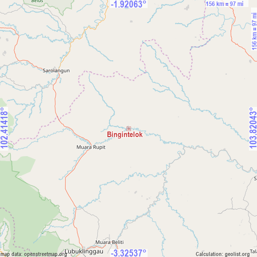
Bingintelok GPS coordinates[2]
2° 37' 23.52" South, 103° 7' 2.28" East
| Map corner | latitude | longitude |
|---|---|---|
| Upper-left | -1.92063°, | 102.41418° |
| Center: | -2.6232°, | 103.1173° |
| Lower-right: | -3.32537°, | 103.82043° |
| Map W x H: | 156.2×156.2 km | = 97.1×97.1mi |
| max Lat: | 5.88969° ⇑8% North |
| Bingintelok: | -2.6232° |
| min Lat: | ⇓92% South -10.934° |
| min Long | Bingintelok | max Long |
| 95.1345° | 103.1173° | 140.9419° |
| W 4.3%⇐ | ⇒95.7% E |
Elevation
Elevation of Bingintelok is 31 m = 102 ft, and this is 198.7 m = 652 ft below average elevation for this country.
| Max E: |
3185 m = 10449 ft | 70.7% |
| Avg. | 229.7 m = 754 ft | |
| Bingintelok | 31 m = 102 ft | |
Min E: |
-1 m = -3 ft | 29.3% |
See also: Indonesia elevation on elevation.city.
Geographical zone
Bingintelok is located in South Torrid zone (between Equator and Tropic of Capricorn). Distance of Equator is 291.7 km =181.3 mi to North.| Distance of | km | miles | from Bingintelok |
|---|---|---|---|
| Equator | 291.7 | 181.3 | to North |
| Tropic Capricorn | 2314.2 | 1438 | to South |
| Antarctic Circle | 7109.5 | 4417.6 | to South |
| South Pole | 9715.4 | 6036.9 | to South |


Nearby cities:
15 places around Bingintelok: (largest is in red/bold)
• Babat
59.5 km =37 mi,  102°
102°
• Bayunglincir
89.2 km =55.4 mi,  44°
44°
• Bejubang Dua
95 km =59 mi,  13°
13°
• Lubuklinggau
79.9 km =49.6 mi,  200°
200°
• Muara Beliti
70.2 km =43.6 mi,  187°
187°
• Muaralakitan
33.5 km =20.8 mi,  141°
141°
• Muaralimun
58.8 km =36.5 mi,  295°
295°
• Muararupit
25.5 km =15.8 mi,  244°
244°
• Padangulaktanding
90.7 km =56.4 mi, 202°
• Pauh
63.3 km =39.3 mi,  328°
328°
• Rantaupangiang
97.3 km =60.5 mi,  278°
278°
• Sarolangun
55.5 km =34.5 mi,  308°
308°
• Sekayu
84.7 km =52.6 mi,  109°
109°
• Surulangun Rawas
39.3 km =24.4 mi,  270°
270°
• Terawas
58.4 km =36.3 mi,  215°
215°
Sources, notices
• [Note1] Compared only with cities in Indonesia existing in our database
• [Src1] Map data: © OpenStreetMap contributors (CC-BY-SA)
• [Src2] Other city data from geonames.org with taken over terms of usage.
• [Src3] Geographical zone / Annual Mean Temperature by Robert A. Rohde @ Wikipedia
