Asera geodata
Asera (Southeast Sulawesi) is a seat of a second-order administrative division; located in Indonesia in Asia/Makassar (GMT+8) time zone. In our database, there are 407 cities with bigger population. Compared to other cities in Indonesia, 90.3% of cities are located further ↓South; 88.2% of cities are located further ←West and 78.9% of cities have higher elevation than Asera. Note1


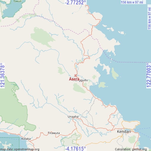
Asera GPS coordinates[2]
3° 28' 28.56" South, 122° 4' 0.84" East
| Map corner | latitude | longitude |
|---|---|---|
| Upper-left | -2.77252°, | 121.36378° |
| Center: | -3.4746°, | 122.0669° |
| Lower-right: | -4.17615°, | 122.77003° |
| Map W x H: | 156.1×156.1 km | = 97×97mi |
| max Lat: | 5.88969° ⇑9.7% North |
| Asera: | -3.4746° |
| min Lat: | ⇓90.3% South -10.934° |
| min Long | Asera | max Long |
| 95.1345° | 122.0669° | 140.9419° |
| W 88.2%⇐ | ⇒11.8% E |
Elevation
Elevation of Asera is 20 m = 66 ft, and this is 209.7 m = 688 ft below average elevation for this country.
| Max E: |
3185 m = 10449 ft | 78.9% |
| Avg. | 229.7 m = 754 ft | |
| Asera | 20 m = 66 ft | |
Min E: |
-1 m = -3 ft | 21.1% |
See also: Indonesia elevation on elevation.city.
Geographical zone
Asera is located in South Torrid zone (between Equator and Tropic of Capricorn). Distance of Equator is 386.3 km =240 mi to North.| Distance of | km | miles | from Asera |
|---|---|---|---|
| Equator | 386.3 | 240 | to North |
| Tropic Capricorn | 2219.6 | 1379.2 | to South |
| Antarctic Circle | 7014.8 | 4358.8 | to South |
| South Pole | 9620.7 | 5978 | to South |


Nearby cities:
15 places around Asera: (largest is in red/bold)
• Andoolo
97 km =60.3 mi,  167°
167°
• Bungku
103.7 km =64.4 mi,  354°
354°
• Katabu
169.7 km =105.4 mi,  162°
162°
• Kendari
74.9 km =46.5 mi,  138°
138°
• Kolaka
82.8 km =51.4 mi,  218°
218°
• Langara
119.4 km =74.2 mi,  120°
120°
• Lasehao
176.8 km =109.9 mi, 164°
• Lasusua
131.3 km =81.6 mi,  268°
268°
• Laworo
154.1 km =95.8 mi, 160°
• Malili
142.7 km =88.7 mi,  310°
310°
• Munse
148.6 km =92.3 mi, 117°
• Raha
168.1 km =104.5 mi,  154°
154°
• Rumbia
128.4 km =79.8 mi,  183°
183°
• Unaaha
42.3 km =26.3 mi, 183°
• Wotu
171.2 km =106.4 mi, 305°
Sources, notices
• [Note1] Compared only with cities in Indonesia existing in our database
• [Src1] Map data: © OpenStreetMap contributors (CC-BY-SA)
• [Src2] Other city data from geonames.org with taken over terms of usage.
• [Src3] Geographical zone / Annual Mean Temperature by Robert A. Rohde @ Wikipedia
