Indramayu geodata
Indramayu (West Java) is a seat of a second-order administrative division; located in Indonesia in Asia/Jakarta (GMT+7) time zone. With population of 123,263 people, there are 106 cities with bigger population in this country. Compared to other cities in Indonesia, 86.5% of cities are located further ↓South; 74.3% of cities are located further →East and 98.5% of cities have higher elevation than Indramayu. Note1


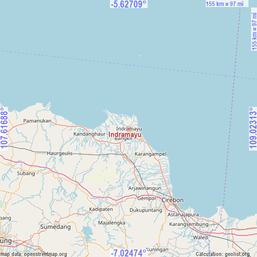
Indramayu GPS coordinates[2]
6° 19' 35.004" South, 108° 19' 12" East
| Map corner | latitude | longitude |
|---|---|---|
| Upper-left | -5.62709°, | 107.61688° |
| Center: | -6.32639°, | 108.32° |
| Lower-right: | -7.02474°, | 109.02313° |
| Map W x H: | 155.4×155.4 km | = 96.6×96.6mi |
| max Lat: | 5.88969° ⇑13.5% North |
| Indramayu: | -6.32639° |
| min Lat: | ⇓86.5% South -10.934° |
| min Long | Indramayu | max Long |
| 95.1345° | 108.32° | 140.9419° |
| W 25.7%⇐ | ⇒74.3% E |
Elevation
Elevation of Indramayu is 5 m = 16 ft, and this is 224.7 m = 737 ft below average elevation for this country.
| Max E: |
3185 m = 10449 ft | 98.5% |
| Avg. | 229.7 m = 754 ft | |
| Indramayu | 5 m = 16 ft | |
Min E: |
-1 m = -3 ft | 1.5% |
See also: Indramayu elevation on elevation.city.
Geographical zone
Indramayu is located in South Torrid zone (between Equator and Tropic of Capricorn). Distance of Equator is 703.4 km =437.1 mi to North.| Distance of | km | miles | from Indramayu |
|---|---|---|---|
| Equator | 703.4 | 437.1 | to North |
| Tropic Capricorn | 1902.5 | 1182.2 | to South |
| Antarctic Circle | 6697.7 | 4161.8 | to South |
| South Pole | 9303.6 | 5781 | to South |


Nearby cities:
15 places around Indramayu: (largest is in red/bold)
• Arjawinangun
36.8 km =22.9 mi,  164°
164°
• Astanajapura
63 km =39.1 mi,  146°
146°
• Cirebon
49.7 km =30.9 mi, 148°
• Jatibarang
16.5 km =10.3 mi,  181°
181°
• Jatiwangi
45.7 km =28.4 mi,  187°
187°
• Karangampel
21 km =13 mi,  136°
136°
• Karangsembung
68.1 km =42.3 mi, 148°
• Klangenan
44.6 km =27.7 mi, 162°
• Majalengka
57.6 km =35.8 mi, 190°
• Palimanan
43.9 km =27.3 mi, 164°
• Pamanukan
56.5 km =35.1 mi,  274°
274°
• Plumbon
45.4 km =28.2 mi, 158°
• Subang
67.9 km =42.2 mi,  246°
246°
• Sumber
51.5 km =32 mi, 159°
• Weru
47.3 km =29.4 mi, 154°
Sources, notices
• [Note1] Compared only with cities in Indonesia existing in our database
• [Src1] Map data: © OpenStreetMap contributors (CC-BY-SA)
• [Src2] Other city data from geonames.org with taken over terms of usage.
• [Src3] Geographical zone / Annual Mean Temperature by Robert A. Rohde @ Wikipedia
