Ardee geodata
Ardee (Leinster) is a populated place; located in Ireland in Europe/Dublin (GMT+1) time zone. With population of 4,008 people, there are 157 cities with bigger population in this country. Compared to other cities in Ireland, 83.7% of cities are located further ↓South; 72.9% of cities are located further ←West and 68.7% of cities have higher elevation than Ardee. Note1


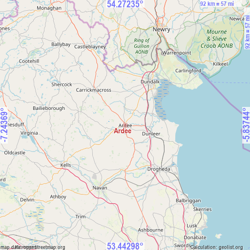
Ardee GPS coordinates[2]
53° 51' 34.992" North, 6° 32' 26.016" West
| Map corner | latitude | longitude |
|---|---|---|
| Upper-left | 54.27235°, | -7.24369° |
| Center: | 53.85972°, | -6.54056° |
| Lower-right: | 53.44298°, | -5.83744° |
| Map W x H: | 92.2×92.2 km | = 57.3×57.3mi |
| max Lat: | 55.25° ⇑16.3% North |
| Ardee: | 53.85972° |
| min Lat: | ⇓83.7% South 51.52487° |
| min Long | Ardee | max Long |
| -10.26889° | -6.54056° | -6.04944° |
| W 72.9%⇐ | ⇒27.1% E |
Elevation
Elevation of Ardee is 27 m = 89 ft, and this is 27.5 m = 90 ft below average elevation for this country.
| Max E: |
262 m = 860 ft | 68.7% |
| Avg. | 54.5 m = 179 ft | |
| Ardee | 27 m = 89 ft | |
Min E: |
0 m = 0 ft | 31.3% |
See also: Ireland elevation on elevation.city.
Geographical zone
Ardee is located in North temperate zone (between Tropic of Cancer and the Arctic Circle). Distance of this North polar circle is 1412.5 km =877.7 mi to North.| Distance of | km | miles | from Ardee |
|---|---|---|---|
| North Pole | 4018.4 | 2496.9 | to North |
| Arctic Circle | 1412.5 | 877.7 | to North |
| Tropic Cancer | 3382.7 | 2101.9 | to South |
| Equator | 5988.6 | 3721.1 | to South |


Nearby cities:
15 places around Ardee: (largest is in red/bold)
• Blackrock
16.3 km =10.1 mi,  44°
44°
• Carrickmacross
17.2 km =10.7 mi,  317°
317°
• Castlebellingham
10.9 km =6.8 mi,  65°
65°
• Collon
9.4 km =5.8 mi,  158°
158°
• Donore
20.2 km =12.6 mi, 156°
• Drogheda
20.1 km =12.5 mi,  141°
141°
• Dromiskin
11.6 km =7.2 mi,  51°
51°
• Dundalk
17.6 km =10.9 mi,  27°
27°
• Dunleer
9.9 km =6.2 mi,  106°
106°
• Kingscourt
18.2 km =11.3 mi,  287°
287°
• Knockbridge
13.1 km =8.1 mi,  15°
15°
• Louth
9.9 km =6.2 mi,  359°
359°
• Slane
16.6 km =10.3 mi,  180°
180°
• Tallanstown
7 km =4.3 mi, 356°
• Tullyallen
15.8 km =9.8 mi,  150°
150°
Sources, notices
• [Note1] Compared only with cities in Ireland existing in our database
• [Src1] Map data: © OpenStreetMap contributors (CC-BY-SA)
• [Src2] Other city data from geonames.org with taken over terms of usage.
• [Src3] Geographical zone / Annual Mean Temperature by Robert A. Rohde @ Wikipedia
