Castlebellingham geodata
Castlebellingham (Leinster) is a populated place; located in Ireland in Europe/Dublin (GMT+1) time zone. With population of 1,035 people, there are 344 cities with bigger population in this country. Compared to other cities in Ireland, 84.4% of cities are located further ↓South; 79.1% of cities are located further ←West and 83.9% of cities have higher elevation than Castlebellingham. Note1


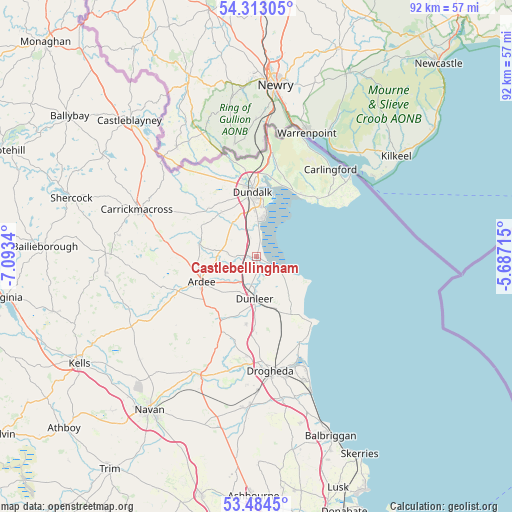
Castlebellingham GPS coordinates[2]
53° 54' 2.988" North, 6° 23' 25.008" West
| Map corner | latitude | longitude |
|---|---|---|
| Upper-left | 54.31305°, | -7.0934° |
| Center: | 53.90083°, | -6.39028° |
| Lower-right: | 53.4845°, | -5.68715° |
| Map W x H: | 92.1×92.1 km | = 57.2×57.2mi |
| max Lat: | 55.25° ⇑15.6% North |
| Castlebellingham: | 53.90083° |
| min Lat: | ⇓84.4% South 51.52487° |
| min Long | Castlebellingha | max Long |
| -10.26889° | -6.39028° | -6.04944° |
| W 79.1%⇐ | ⇒20.9% E |
Elevation
Elevation of Castlebellingham is 14 m = 46 ft, and this is 40.5 m = 133 ft below average elevation for this country.
| Max E: |
262 m = 860 ft | 83.9% |
| Avg. | 54.5 m = 179 ft | |
| Castlebellingham | 14 m = 46 ft | |
Min E: |
0 m = 0 ft | 16.1% |
See also: Ireland elevation on elevation.city.
Geographical zone
Castlebellingham is located in North temperate zone (between Tropic of Cancer and the Arctic Circle). Distance of this North polar circle is 1408 km =874.9 mi to North.| Distance of | km | miles | from Castlebellingham |
|---|---|---|---|
| North Pole | 4013.9 | 2494.1 | to North |
| Arctic Circle | 1408 | 874.9 | to North |
| Tropic Cancer | 3387.3 | 2104.8 | to South |
| Equator | 5993.2 | 3724 | to South |


Nearby cities:
15 places around Castlebellingham: (largest is in red/bold)
• Ardee
10.9 km =6.8 mi,  245°
245°
• Blackrock
7.2 km =4.5 mi,  13°
13°
• Carlingford
20.3 km =12.6 mi,  40°
40°
• Clogherhead
15.6 km =9.7 mi,  139°
139°
• Collon
14.7 km =9.1 mi,  205°
205°
• Drogheda
20.4 km =12.7 mi,  172°
172°
• Dromiskin
2.9 km =1.8 mi,  343°
343°
• Dundalk
11.2 km =7 mi,  351°
351°
• Dunleer
7.3 km =4.5 mi,  182°
182°
• Knockbridge
10.2 km =6.3 mi,  322°
322°
• Louth
11.2 km =7 mi,  298°
298°
• Omeath
22.7 km =14.1 mi,  22°
22°
• Tallanstown
10.5 km =6.5 mi,  283°
283°
• Termonfeckin
17.3 km =10.7 mi,  152°
152°
• Tullyallen
18.4 km =11.4 mi,  186°
186°
Sources, notices
• [Note1] Compared only with cities in Ireland existing in our database
• [Src1] Map data: © OpenStreetMap contributors (CC-BY-SA)
• [Src2] Other city data from geonames.org with taken over terms of usage.
• [Src3] Geographical zone / Annual Mean Temperature by Robert A. Rohde @ Wikipedia
