Portlaoise geodata
Portlaoise (Leinster) is a seat of a second-order administrative division; located in Ireland in Europe/Dublin (GMT+1) time zone. With population of 13,622 people, there are 37 cities with bigger population in this country. Compared to other cities in Ireland, 60% of cities are located further ↑North; 52.2% of cities are located further ←West and 88% of cities have lower elevation than Portlaoise. Note1


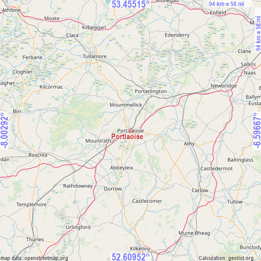
Portlaoise GPS coordinates[2]
53° 2' 3.876" North, 7° 17' 59.244" West
| Map corner | latitude | longitude |
|---|---|---|
| Upper-left | 53.45515°, | -8.00292° |
| Center: | 53.03441°, | -7.29979° |
| Lower-right: | 52.60952°, | -6.59667° |
| Map W x H: | 94×94 km | = 58.4×58.4mi |
| max Lat: | 55.25° ⇑60% North |
| Portlaoise: | 53.03441° |
| min Lat: | ⇓40% South 51.52487° |
| min Long | Portlaoise | max Long |
| -10.26889° | -7.29979° | -6.04944° |
| W 52.2%⇐ | ⇒47.8% E |
Elevation
Elevation of Portlaoise is 101 m = 331 ft, and this is 46.5 m = 153 ft above average elevation for this country.
| Max E: |
262 m = 860 ft | 12% |
| Portlaoise | 101 m 331 ft | |
| Avg. | 54.5 m = 179 ft | |
Min E: |
0 m = 0 ft | 88% |
See also: Ireland elevation on elevation.city.
Geographical zone
Portlaoise is located in North temperate zone (between Tropic of Cancer and the Arctic Circle). Distance of this North polar circle is 1504.3 km =934.7 mi to North.| Distance of | km | miles | from Portlaoise |
|---|---|---|---|
| North Pole | 4110.2 | 2554 | to North |
| Arctic Circle | 1504.3 | 934.7 | to North |
| Tropic Cancer | 3291 | 2044.9 | to South |
| Equator | 5896.9 | 3664.2 | to South |


Nearby cities:
15 places around Portlaoise: (largest is in red/bold)
• Abbeyleix
13.8 km =8.6 mi,  192°
192°
• Athy
21.9 km =13.6 mi,  102°
102°
• Ballylinan
20 km =12.4 mi,  119°
119°
• Ballyragget
27.4 km =17 mi,  184°
184°
• Castlecomer
26.1 km =16.2 mi,  166°
166°
• Cherryville
26.1 km =16.2 mi,  58°
58°
• Clonaslee
19.6 km =12.2 mi,  309°
309°
• Durrow
22 km =13.7 mi,  196°
196°
• Killenard
14.9 km =9.3 mi,  42°
42°
• Monasterevin
19.6 km =12.2 mi,  52°
52°
• Moneenroe
23.7 km =14.7 mi,  155°
155°
• Mountmellick
8.9 km =5.5 mi,  351°
351°
• Mountrath
12.2 km =7.6 mi,  251°
251°
• Portarlington
16 km =9.9 mi,  27°
27°
• Stradbally
10.1 km =6.3 mi, 102°
Sources, notices
• [Note1] Compared only with cities in Ireland existing in our database
• [Src1] Map data: © OpenStreetMap contributors (CC-BY-SA)
• [Src2] Other city data from geonames.org with taken over terms of usage.
• [Src3] Geographical zone / Annual Mean Temperature by Robert A. Rohde @ Wikipedia
