Rochfortbridge geodata
Rochfortbridge (Leinster) is a populated place; located in Ireland in Europe/Dublin (GMT+1) time zone. With population of 1,494 people, there are 276 cities with bigger population in this country. Compared to other cities in Ireland, 67.9% of cities are located further ↓South; 52.6% of cities are located further ←West and 78.4% of cities have lower elevation than Rochfortbridge. Note1


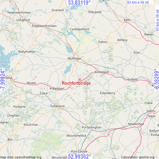
Rochfortbridge GPS coordinates[2]
53° 24' 51.012" North, 7° 17' 45.996" West
| Map corner | latitude | longitude |
|---|---|---|
| Upper-left | 53.83119°, | -7.99924° |
| Center: | 53.41417°, | -7.29611° |
| Lower-right: | 52.99302°, | -6.59299° |
| Map W x H: | 93.2×93.2 km | = 57.9×57.9mi |
| max Lat: | 55.25° ⇑32.1% North |
| Rochfortbridge: | 53.41417° |
| min Lat: | ⇓67.9% South 51.52487° |
| min Long | Rochfortbridge | max Long |
| -10.26889° | -7.29611° | -6.04944° |
| W 52.6%⇐ | ⇒47.4% E |
Elevation
Elevation of Rochfortbridge is 86 m = 282 ft, and this is 31.5 m = 103 ft above average elevation for this country.
| Max E: |
262 m = 860 ft | 21.6% |
| Rochfortbridge | 86 m 282 ft | |
| Avg. | 54.5 m = 179 ft | |
Min E: |
0 m = 0 ft | 78.4% |
See also: Ireland elevation on elevation.city.
Geographical zone
Rochfortbridge is located in North temperate zone (between Tropic of Cancer and the Arctic Circle). Distance of this North polar circle is 1462.1 km =908.5 mi to North.| Distance of | km | miles | from Rochfortbridge |
|---|---|---|---|
| North Pole | 4068 | 2527.7 | to North |
| Arctic Circle | 1462.1 | 908.5 | to North |
| Tropic Cancer | 3333.2 | 2071.2 | to South |
| Equator | 5939.1 | 3690.4 | to South |


Nearby cities:
15 places around Rochfortbridge: (largest is in red/bold)
• An Muileann gCearr
12.6 km =7.8 mi,  347°
347°
• Ballivor
25.7 km =16 mi,  59°
59°
• Clara
22.5 km =14 mi,  249°
249°
• Daingean
13.1 km =8.1 mi,  178°
178°
• Delvin
25.7 km =16 mi,  31°
31°
• Derrinturn
24.9 km =15.5 mi,  108°
108°
• Edenderry
18.5 km =11.5 mi,  116°
116°
• Kilbeggan
14.6 km =9.1 mi, 250°
• Kinnegad
13.7 km =8.5 mi,  71°
71°
• Longwood
25.2 km =15.7 mi,  79°
79°
• Moate
28 km =17.4 mi,  265°
265°
• Rathwire
14.9 km =9.3 mi,  45°
45°
• Rhode
9.3 km =5.8 mi,  137°
137°
• Tullamore
20.2 km =12.6 mi,  219°
219°
• Tyrrellspass
5.9 km =3.7 mi,  241°
241°
Sources, notices
• [Note1] Compared only with cities in Ireland existing in our database
• [Src1] Map data: © OpenStreetMap contributors (CC-BY-SA)
• [Src2] Other city data from geonames.org with taken over terms of usage.
• [Src3] Geographical zone / Annual Mean Temperature by Robert A. Rohde @ Wikipedia
