Nenagh Bridge geodata
Nenagh Bridge (Munster) is a populated place; located in Ireland in Europe/Dublin (GMT+1) time zone. With population of 6,672 people, there are 104 cities with bigger population in this country. Compared to other cities in Ireland, 64.7% of cities are located further ↑North; 66% of cities are located further →East and 50.7% of cities have lower elevation than Nenagh Bridge. Note1


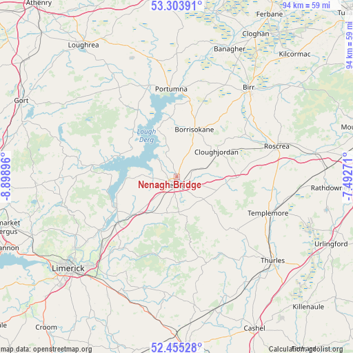
Nenagh Bridge GPS coordinates[2]
52° 52' 54.012" North, 8° 11' 44.988" West
| Map corner | latitude | longitude |
|---|---|---|
| Upper-left | 53.30391°, | -8.89896° |
| Center: | 52.88167°, | -8.19583° |
| Lower-right: | 52.45528°, | -7.49271° |
| Map W x H: | 94.4×94.4 km | = 58.7×58.7mi |
| max Lat: | 55.25° ⇑64.7% North |
| Nenagh Bridge: | 52.88167° |
| min Lat: | ⇓35.3% South 51.52487° |
| min Long | Nenagh Bridge | max Long |
| -10.26889° | -8.19583° | -6.04944° |
| W 34%⇐ | ⇒66% E |
Elevation
Elevation of Nenagh Bridge is 52 m = 171 ft, and this is 2.5 m = 8 ft below average elevation for this country.
| Max E: |
262 m = 860 ft | 49.3% |
| Avg. | 54.5 m = 179 ft | |
| Nenagh Bridge | 52 m = 171 ft | |
Min E: |
0 m = 0 ft | 50.7% |
See also: Ireland elevation on elevation.city.
Geographical zone
Nenagh Bridge is located in North temperate zone (between Tropic of Cancer and the Arctic Circle). Distance of this North polar circle is 1521.3 km =945.3 mi to North.| Distance of | km | miles | from Nenagh Bridge |
|---|---|---|---|
| North Pole | 4127.2 | 2564.5 | to North |
| Arctic Circle | 1521.3 | 945.3 | to North |
| Tropic Cancer | 3274 | 2034.4 | to South |
| Equator | 5879.9 | 3653.6 | to South |


Nearby cities:
15 places around Nenagh Bridge: (largest is in red/bold)
• Ballina
18.1 km =11.2 mi,  242°
242°
• Borrisokane
13.4 km =8.3 mi,  19°
19°
• Borrisoleigh
21.8 km =13.5 mi,  131°
131°
• Castleconnell
27.7 km =17.2 mi,  227°
227°
• Clonlara
29.7 km =18.5 mi, 233°
• Cloughjordan
12.6 km =7.8 mi,  58°
58°
• Killaloe
18.6 km =11.6 mi, 243°
• Moroe
29 km =18 mi,  207°
207°
• Nenagh
2.2 km =1.4 mi,  181°
181°
• Newport
23.8 km =14.8 mi,  217°
217°
• Portumna
23.1 km =14.4 mi,  356°
356°
• Roscrea
27.5 km =17.1 mi,  73°
73°
• Scarriff
22.8 km =14.2 mi,  277°
277°
• Shinrone
21.4 km =13.3 mi, 58°
• Templemore
26.2 km =16.3 mi,  111°
111°
Sources, notices
• [Note1] Compared only with cities in Ireland existing in our database
• [Src1] Map data: © OpenStreetMap contributors (CC-BY-SA)
• [Src2] Other city data from geonames.org with taken over terms of usage.
• [Src3] Geographical zone / Annual Mean Temperature by Robert A. Rohde @ Wikipedia
