Nenagh geodata
Nenagh (Munster) is a seat of a first-order administrative division; located in Ireland in Europe/Dublin (GMT+1) time zone. With population of 5,500 people, there are 124 cities with bigger population in this country. Compared to other cities in Ireland, 65.5% of cities are located further ↑North; 66.2% of cities are located further →East and 50.7% of cities have lower elevation than Nenagh. Note1


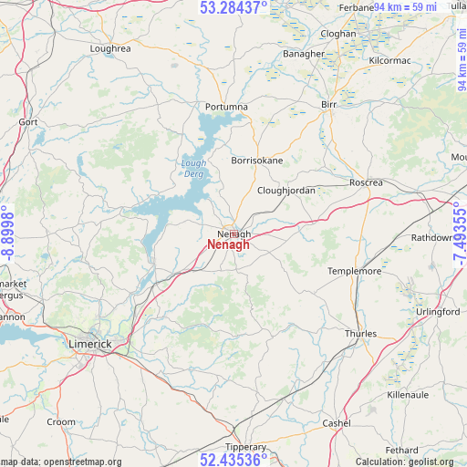
Nenagh GPS coordinates[2]
52° 51' 42.984" North, 8° 11' 48.012" West
| Map corner | latitude | longitude |
|---|---|---|
| Upper-left | 53.28437°, | -8.8998° |
| Center: | 52.86194°, | -8.19667° |
| Lower-right: | 52.43536°, | -7.49355° |
| Map W x H: | 94.4×94.4 km | = 58.7×58.7mi |
| max Lat: | 55.25° ⇑65.5% North |
| Nenagh: | 52.86194° |
| min Lat: | ⇓34.5% South 51.52487° |
| min Long | Nenagh | max Long |
| -10.26889° | -8.19667° | -6.04944° |
| W 33.8%⇐ | ⇒66.2% E |
Elevation
Elevation of Nenagh is 52 m = 171 ft, and this is 2.5 m = 8 ft below average elevation for this country.
| Max E: |
262 m = 860 ft | 49.3% |
| Avg. | 54.5 m = 179 ft | |
| Nenagh | 52 m = 171 ft | |
Min E: |
0 m = 0 ft | 50.7% |
See also: Ireland elevation on elevation.city.
Geographical zone
Nenagh is located in North temperate zone (between Tropic of Cancer and the Arctic Circle). Distance of this North polar circle is 1523.5 km =946.7 mi to North.| Distance of | km | miles | from Nenagh |
|---|---|---|---|
| North Pole | 4129.4 | 2565.9 | to North |
| Arctic Circle | 1523.5 | 946.7 | to North |
| Tropic Cancer | 3271.8 | 2033 | to South |
| Equator | 5877.7 | 3652.2 | to South |


Nearby cities:
15 places around Nenagh: (largest is in red/bold)
• Ballina
17.1 km =10.6 mi,  249°
249°
• Borrisokane
15.5 km =9.6 mi,  17°
17°
• Borrisoleigh
20.4 km =12.7 mi,  126°
126°
• Castleconnell
26.2 km =16.3 mi,  231°
231°
• Clonlara
28.4 km =17.6 mi,  237°
237°
• Cloughjordan
13.9 km =8.6 mi,  51°
51°
• Killaloe
17.7 km =11 mi, 249°
• Moroe
27 km =16.8 mi,  209°
209°
• Nenagh Bridge
2.2 km =1.4 mi,  1°
1°
• Newport
22.1 km =13.7 mi,  220°
220°
• Portumna
25.3 km =15.7 mi,  356°
356°
• Roscrea
28.3 km =17.6 mi,  69°
69°
• Scarriff
23.2 km =14.4 mi,  282°
282°
• Shinrone
22.6 km =14 mi, 53°
• Templemore
25.5 km =15.8 mi,  107°
107°
Sources, notices
• [Note1] Compared only with cities in Ireland existing in our database
• [Src1] Map data: © OpenStreetMap contributors (CC-BY-SA)
• [Src2] Other city data from geonames.org with taken over terms of usage.
• [Src3] Geographical zone / Annual Mean Temperature by Robert A. Rohde @ Wikipedia
