Killaloe geodata
Killaloe (Munster) is a populated place; located in Ireland in Europe/Dublin (GMT+1) time zone. With population of 1,292 people, there are 300 cities with bigger population in this country. Compared to other cities in Ireland, 67.9% of cities are located further ↑North; 72.9% of cities are located further →East and 54.1% of cities have lower elevation than Killaloe. Note1


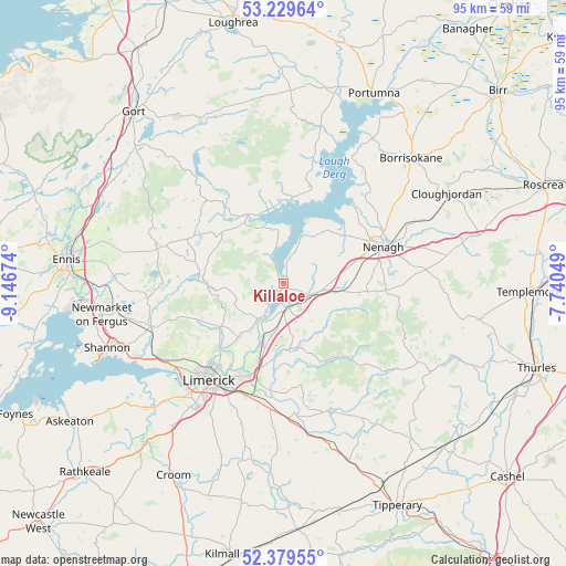
Killaloe GPS coordinates[2]
52° 48' 24.012" North, 8° 26' 36.996" West
| Map corner | latitude | longitude |
|---|---|---|
| Upper-left | 53.22964°, | -9.14674° |
| Center: | 52.80667°, | -8.44361° |
| Lower-right: | 52.37955°, | -7.74049° |
| Map W x H: | 94.5×94.5 km | = 58.7×58.7mi |
| max Lat: | 55.25° ⇑67.9% North |
| Killaloe: | 52.80667° |
| min Lat: | ⇓32.1% South 51.52487° |
| min Long | Killaloe | max Long |
| -10.26889° | -8.44361° | -6.04944° |
| W 27.1%⇐ | ⇒72.9% E |
Elevation
Elevation of Killaloe is 55 m = 180 ft, and this is 0.5 m = 2 ft above average elevation for this country.
| Max E: |
262 m = 860 ft | 45.9% |
| Killaloe | 55 m 180 ft | |
| Avg. | 54.5 m = 179 ft | |
Min E: |
0 m = 0 ft | 54.1% |
See also: Ireland elevation on elevation.city.
Geographical zone
Killaloe is located in North temperate zone (between Tropic of Cancer and the Arctic Circle). Distance of this North polar circle is 1529.6 km =950.4 mi to North.| Distance of | km | miles | from Killaloe |
|---|---|---|---|
| North Pole | 4135.5 | 2569.7 | to North |
| Arctic Circle | 1529.6 | 950.4 | to North |
| Tropic Cancer | 3265.6 | 2029.1 | to South |
| Equator | 5871.6 | 3648.4 | to South |


Nearby cities:
15 places around Killaloe: (largest is in red/bold)
• Annacotty
16.5 km =10.3 mi,  200°
200°
• Ardnacrusha
15.8 km =9.8 mi,  226°
226°
• Ballina
0.6 km =0.4 mi,  77°
77°
• Ballycannan
18.2 km =11.3 mi, 230°
• Castleconnell
11 km =6.8 mi, 200°
• Clonlara
11.7 km =7.3 mi,  218°
218°
• Kilkishen
20.3 km =12.6 mi,  270°
270°
• Luimneach
19.9 km =12.4 mi, 217°
• Moroe
17.6 km =10.9 mi,  169°
169°
• Moyross
19.1 km =11.9 mi, 223°
• Nenagh
17.7 km =11 mi,  69°
69°
• Nenagh Bridge
18.6 km =11.6 mi,  63°
63°
• Newport
10.9 km =6.8 mi, 167°
• Scarriff
12.8 km =8 mi,  332°
332°
• Tulla
22.2 km =13.8 mi,  286°
286°
Sources, notices
• [Note1] Compared only with cities in Ireland existing in our database
• [Src1] Map data: © OpenStreetMap contributors (CC-BY-SA)
• [Src2] Other city data from geonames.org with taken over terms of usage.
• [Src3] Geographical zone / Annual Mean Temperature by Robert A. Rohde @ Wikipedia
