Portlaw geodata
Portlaw (Munster) is a populated place; located in Ireland in Europe/Dublin (GMT+1) time zone. With population of 1,696 people, there are 253 cities with bigger population in this country. Compared to other cities in Ireland, 85.8% of cities are located further ↑North; 51.6% of cities are located further ←West and 74.2% of cities have higher elevation than Portlaw. Note1


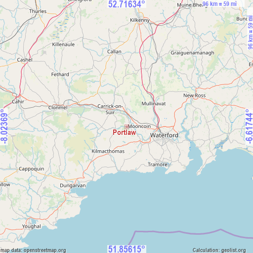
Portlaw GPS coordinates[2]
52° 17' 17.988" North, 7° 19' 14.016" West
| Map corner | latitude | longitude |
|---|---|---|
| Upper-left | 52.71634°, | -8.02369° |
| Center: | 52.28833°, | -7.32056° |
| Lower-right: | 51.85615°, | -6.61744° |
| Map W x H: | 95.6×95.6 km | = 59.4×59.4mi |
| max Lat: | 55.25° ⇑85.8% North |
| Portlaw: | 52.28833° |
| min Lat: | ⇓14.2% South 51.52487° |
| min Long | Portlaw | max Long |
| -10.26889° | -7.32056° | -6.04944° |
| W 51.6%⇐ | ⇒48.4% E |
Elevation
Elevation of Portlaw is 22 m = 72 ft, and this is 32.5 m = 107 ft below average elevation for this country.
| Max E: |
262 m = 860 ft | 74.2% |
| Avg. | 54.5 m = 179 ft | |
| Portlaw | 22 m = 72 ft | |
Min E: |
0 m = 0 ft | 25.8% |
See also: Ireland elevation on elevation.city.
Geographical zone
Portlaw is located in North temperate zone (between Tropic of Cancer and the Arctic Circle). Distance of this North polar circle is 1587.3 km =986.3 mi to North.| Distance of | km | miles | from Portlaw |
|---|---|---|---|
| North Pole | 4193.1 | 2605.5 | to North |
| Arctic Circle | 1587.3 | 986.3 | to North |
| Tropic Cancer | 3208 | 1993.4 | to South |
| Equator | 5813.9 | 3612.6 | to South |


Nearby cities:
15 places around Portlaw: (largest is in red/bold)
• Callan
28.9 km =18 mi,  350°
350°
• Carrick-on-Suir
9.2 km =5.7 mi,  317°
317°
• Cluain Meala
27.1 km =16.8 mi,  285°
285°
• Dungarvan
30.5 km =19 mi,  223°
223°
• Dunmore East
26.7 km =16.6 mi,  124°
124°
• Kilmacow
10.2 km =6.3 mi,  71°
71°
• Kilmacthomas
11.7 km =7.3 mi, 217°
• Kilsheelan
19.2 km =11.9 mi, 294°
• Mooncoin
4.9 km =3 mi,  88°
88°
• New Ross
28.7 km =17.8 mi, 65°
• Passage East
24.5 km =15.2 mi,  105°
105°
• Piltown
7.4 km =4.6 mi, 349°
• Thomastown
29.3 km =18.2 mi,  25°
25°
• Trá Mhór
18.1 km =11.2 mi,  140°
140°
• Waterford
14.6 km =9.1 mi,  103°
103°
Sources, notices
• [Note1] Compared only with cities in Ireland existing in our database
• [Src1] Map data: © OpenStreetMap contributors (CC-BY-SA)
• [Src2] Other city data from geonames.org with taken over terms of usage.
• [Src3] Geographical zone / Annual Mean Temperature by Robert A. Rohde @ Wikipedia
