Taghmon geodata
Taghmon (Leinster) is a populated place; located in Ireland in Europe/Dublin (GMT+1) time zone. With population of 623 people, there are 470 cities with bigger population in this country. Compared to other cities in Ireland, 85% of cities are located further ↑North; 70.2% of cities are located further ←West and 63.9% of cities have lower elevation than Taghmon. Note1


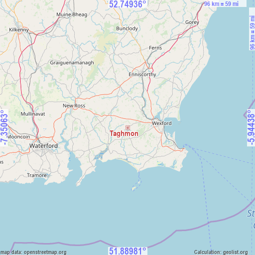
Taghmon GPS coordinates[2]
52° 19' 18.012" North, 6° 38' 51" West
| Map corner | latitude | longitude |
|---|---|---|
| Upper-left | 52.74936°, | -7.35063° |
| Center: | 52.32167°, | -6.6475° |
| Lower-right: | 51.88981°, | -5.94438° |
| Map W x H: | 95.6×95.6 km | = 59.4×59.4mi |
| max Lat: | 55.25° ⇑85% North |
| Taghmon: | 52.32167° |
| min Lat: | ⇓15% South 51.52487° |
| min Long | Taghmon | max Long |
| -10.26889° | -6.6475° | -6.04944° |
| W 70.2%⇐ | ⇒29.8% E |
Elevation
Elevation of Taghmon is 63 m = 207 ft, and this is 8.5 m = 28 ft above average elevation for this country.
| Max E: |
262 m = 860 ft | 36.1% |
| Taghmon | 63 m 207 ft | |
| Avg. | 54.5 m = 179 ft | |
Min E: |
0 m = 0 ft | 63.9% |
See also: Ireland elevation on elevation.city.
Geographical zone
Taghmon is located in North temperate zone (between Tropic of Cancer and the Arctic Circle). Distance of this North polar circle is 1583.5 km =983.9 mi to North.| Distance of | km | miles | from Taghmon |
|---|---|---|---|
| North Pole | 4189.4 | 2603.2 | to North |
| Arctic Circle | 1583.5 | 983.9 | to North |
| Tropic Cancer | 3211.7 | 1995.7 | to South |
| Equator | 5817.6 | 3614.9 | to South |


Nearby cities:
15 places around Taghmon: (largest is in red/bold)
• Ballinroad
27.3 km =17 mi,  36°
36°
• Ballygerry
21.3 km =13.2 mi,  112°
112°
• Castlebridge
15.3 km =9.5 mi,  61°
61°
• Dunmore East
30.5 km =19 mi,  231°
231°
• Enniscorthy
20.8 km =12.9 mi,  16°
16°
• Ferns
31.3 km =19.4 mi, 18°
• Ford
32.7 km =20.3 mi,  49°
49°
• Graiguenamanagh
32 km =19.9 mi,  319°
319°
• Kilrane
21.7 km =13.5 mi, 114°
• Loch Garman
13 km =8.1 mi,  83°
83°
• New Ross
21.3 km =13.2 mi,  293°
293°
• Passage East
24.4 km =15.2 mi,  245°
245°
• Piercetown
11.5 km =7.1 mi, 111°
• Rosslare
18.6 km =11.6 mi, 105°
• Waterford
32.4 km =20.1 mi,  257°
257°
Sources, notices
• [Note1] Compared only with cities in Ireland existing in our database
• [Src1] Map data: © OpenStreetMap contributors (CC-BY-SA)
• [Src2] Other city data from geonames.org with taken over terms of usage.
• [Src3] Geographical zone / Annual Mean Temperature by Robert A. Rohde @ Wikipedia
