Dunmore East geodata
Dunmore East (Munster) is a populated place; located in Ireland in Europe/Dublin (GMT+1) time zone. With population of 1,559 people, there are 264 cities with bigger population in this country. Compared to other cities in Ireland, 89.6% of cities are located further ↑North; 58.6% of cities are located further ←West and 54.1% of cities have lower elevation than Dunmore East. Note1


Dunmore East GPS coordinates[2]
52° 9' 3.888" North, 6° 59' 55.392" West
| Map corner | latitude | longitude |
|---|---|---|
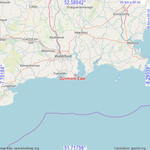
| Upper-left | 52.58042°, | -7.70184° |
| Center: | 52.15108°, | -6.99872° |
| Lower-right: | 51.71756°, | -6.29559° |
| Map W x H: | 95.9×95.9 km | = 59.6×59.6mi |
| max Lat: | 55.25° ⇑89.6% North |
| Dunmore East: | 52.15108° |
| min Lat: | ⇓10.4% South 51.52487° |
| min Long | Dunmore East | max Long |
| -10.26889° | -6.99872° | -6.04944° |
| W 58.6%⇐ | ⇒41.4% E |
Elevation
Elevation of Dunmore East is 55 m = 180 ft, and this is 0.5 m = 2 ft above average elevation for this country.
| Max E: |
262 m = 860 ft | 45.9% |
| Dunmore East | 55 m 180 ft | |
| Avg. | 54.5 m = 179 ft | |
Min E: |
0 m = 0 ft | 54.1% |
See also: Ireland elevation on elevation.city.
Geographical zone
Dunmore East is located in North temperate zone (between Tropic of Cancer and the Arctic Circle). Distance of this North polar circle is 1602.5 km =995.7 mi to North.| Distance of | km | miles | from Dunmore East |
|---|---|---|---|
| North Pole | 4208.4 | 2615 | to North |
| Arctic Circle | 1602.5 | 995.7 | to North |
| Tropic Cancer | 3192.7 | 1983.9 | to South |
| Equator | 5798.7 | 3603.1 | to South |


Nearby cities:
15 places around Dunmore East: (largest is in red/bold)
• Carrick-on-Suir
35.8 km =22.2 mi,  307°
307°
• Dungarvan
43.3 km =26.9 mi,  260°
260°
• Kilmacow
22.1 km =13.7 mi,  326°
326°
• Kilmacthomas
29.7 km =18.5 mi,  281°
281°
• Loch Garman
42.1 km =26.2 mi,  61°
61°
• Mooncoin
22.9 km =14.2 mi, 312°
• New Ross
27.6 km =17.1 mi,  8°
8°
• Passage East
9 km =5.6 mi, 10°
• Piercetown
37.7 km =23.4 mi,  66°
66°
• Piltown
32.3 km =20.1 mi, 314°
• Portlaw
26.7 km =16.6 mi,  304°
304°
• Taghmon
30.5 km =19 mi,  51°
51°
• Thomastown
42.8 km =26.6 mi,  347°
347°
• Trá Mhór
10.6 km =6.6 mi, 276°
• Waterford
14.2 km =8.8 mi, 327°
Sources, notices
• [Note1] Compared only with cities in Ireland existing in our database
• [Src1] Map data: © OpenStreetMap contributors (CC-BY-SA)
• [Src2] Other city data from geonames.org with taken over terms of usage.
• [Src3] Geographical zone / Annual Mean Temperature by Robert A. Rohde @ Wikipedia
