An Muileann gCearr geodata
An Muileann gCearr (Leinster) is a seat of a second-order administrative division; located in Ireland in Europe/Dublin (GMT+1) time zone. With population of 17,262 people, there are 24 cities with bigger population in this country. Compared to other cities in Ireland, 73.1% of cities are located further ↓South; 51.2% of cities are located further ←West and 92.4% of cities have lower elevation than An Muileann gCearr. Note1


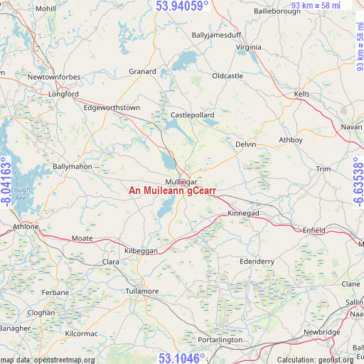
An Muileann gCearr GPS coordinates[2]
53° 31' 28.776" North, 7° 20' 18.6" West
| Map corner | latitude | longitude |
|---|---|---|
| Upper-left | 53.94059°, | -8.04163° |
| Center: | 53.52466°, | -7.3385° |
| Lower-right: | 53.1046°, | -6.63538° |
| Map W x H: | 93×93 km | = 57.8×57.8mi |
| max Lat: | 55.25° ⇑26.9% North |
| An Muileann gCearr: | 53.52466° |
| min Lat: | ⇓73.1% South 51.52487° |
| min Long | An Muileann gCe | max Long |
| -10.26889° | -7.3385° | -6.04944° |
| W 51.2%⇐ | ⇒48.8% E |
Elevation
Elevation of An Muileann gCearr is 113 m = 371 ft, and this is 58.5 m = 192 ft above average elevation for this country.
| Max E: |
262 m = 860 ft | 7.6% |
| An Muileann gCearr | 113 m 371 ft | |
| Avg. | 54.5 m = 179 ft | |
Min E: |
0 m = 0 ft | 92.4% |
See also: Ireland elevation on elevation.city.
Geographical zone
An Muileann gCearr is located in North temperate zone (between Tropic of Cancer and the Arctic Circle). Distance of this North polar circle is 1449.8 km =900.9 mi to North.| Distance of | km | miles | from An Muileann gCearr |
|---|---|---|---|
| North Pole | 4055.7 | 2520.1 | to North |
| Arctic Circle | 1449.8 | 900.9 | to North |
| Tropic Cancer | 3345.5 | 2078.8 | to South |
| Equator | 5951.4 | 3698 | to South |


Nearby cities:
15 places around An Muileann gCearr: (largest is in red/bold)
• Ballivor
25 km =15.5 mi,  88°
88°
• Castlepollard
17.4 km =10.8 mi,  8°
8°
• Clara
27.3 km =17 mi,  222°
222°
• Clonmellon
26.2 km =16.3 mi,  53°
53°
• Daingean
25.6 km =15.9 mi,  172°
172°
• Delvin
18.8 km =11.7 mi,  59°
59°
• Edenderry
28.2 km =17.5 mi,  136°
136°
• Edgeworthstown
26.8 km =16.7 mi,  316°
316°
• Kilbeggan
20.4 km =12.7 mi,  212°
212°
• Kinnegad
17.7 km =11 mi,  117°
117°
• Moate
25.1 km =15.6 mi,  276°
276°
• Rathwire
13.6 km =8.5 mi,  97°
97°
• Rhode
21.2 km =13.2 mi,  154°
154°
• Rochfortbridge
12.6 km =7.8 mi, 167°
• Tyrrellspass
15.3 km =9.5 mi,  188°
188°
Sources, notices
• [Note1] Compared only with cities in Ireland existing in our database
• [Src1] Map data: © OpenStreetMap contributors (CC-BY-SA)
• [Src2] Other city data from geonames.org with taken over terms of usage.
• [Src3] Geographical zone / Annual Mean Temperature by Robert A. Rohde @ Wikipedia
