Kinnegad geodata
Kinnegad (Leinster) is a populated place; located in Ireland in Europe/Dublin (GMT+0) time zone. With population of 2,662 people, there are 197 cities with bigger population in this country. Compared to other cities in Ireland, 69.6% of cities are located further ↓South; 56.5% of cities are located further ←West and 69.6% of cities have lower elevation than Kinnegad. Note1


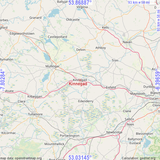
Kinnegad GPS coordinates[2]
53° 27' 7.992" North, 7° 5' 58.992" West
| Map corner | latitude | longitude |
|---|---|---|
| Upper-left | 53.86887°, | -7.80284° |
| Center: | 53.45222°, | -7.09972° |
| Lower-right: | 53.03145°, | -6.39659° |
| Map W x H: | 93.1×93.1 km | = 57.8×57.8mi |
| max Lat: | 55.25° ⇑30.4% North |
| Kinnegad: | 53.45222° |
| min Lat: | ⇓69.6% South 51.52487° |
| min Long | Kinnegad | max Long |
| -10.26889° | -7.09972° | -6.04944° |
| W 56.5%⇐ | ⇒43.5% E |
Elevation
Elevation of Kinnegad is 70 m = 230 ft, and this is 15.5 m = 51 ft above average elevation for this country.
| Max E: |
262 m = 860 ft | 30.4% |
| Kinnegad | 70 m 230 ft | |
| Avg. | 54.5 m = 179 ft | |
Min E: |
0 m = 0 ft | 69.6% |
See also: Ireland elevation on elevation.city.
Geographical zone
Kinnegad is located in North temperate zone (between Tropic of Cancer and the Arctic Circle). Distance of this North polar circle is 1457.8 km =905.8 mi to North.| Distance of | km | miles | from Kinnegad |
|---|---|---|---|
| North Pole | 4063.7 | 2525.1 | to North |
| Arctic Circle | 1457.8 | 905.8 | to North |
| Tropic Cancer | 3337.4 | 2073.8 | to South |
| Equator | 5943.3 | 3693 | to South |


Nearby cities:
15 places around Kinnegad: (largest is in red/bold)
• An Muileann gCearr
17.7 km =11 mi,  297°
297°
• Athboy
22.6 km =14 mi,  32°
32°
• Ballivor
12.7 km =7.9 mi,  46°
46°
• Daingean
21.4 km =13.3 mi,  215°
215°
• Delvin
17.6 km =10.9 mi,  1°
1°
• Derrinturn
16.2 km =10.1 mi,  139°
139°
• Edenderry
13 km =8.1 mi,  164°
164°
• Enfield
18.2 km =11.3 mi,  103°
103°
• Johnstown Bridge
16.8 km =10.4 mi,  108°
108°
• Kildalkey
18.4 km =11.4 mi,  44°
44°
• Longwood
11.8 km =7.3 mi,  89°
89°
• Rathwire
6.6 km =4.1 mi,  339°
339°
• Rhode
13 km =8.1 mi,  211°
211°
• Rochfortbridge
13.7 km =8.5 mi,  251°
251°
• Tyrrellspass
19.5 km =12.1 mi, 248°
Sources, notices
• [Note1] Compared only with cities in Ireland existing in our database
• [Src1] Map data: © OpenStreetMap contributors (CC-BY-SA)
• [Src2] Other city data from geonames.org with taken over terms of usage.
• [Src3] Geographical zone / Annual Mean Temperature by Robert A. Rohde @ Wikipedia
