Celbridge geodata
Celbridge (Leinster) is a populated place; located in Ireland in Europe/Dublin (GMT+1) time zone. With population of 19,537 people, there are 21 cities with bigger population in this country. Compared to other cities in Ireland, 59.8% of cities are located further ↓South; 72.3% of cities are located further ←West and 53.1% of cities have lower elevation than Celbridge. Note1


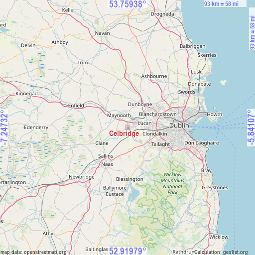
Celbridge GPS coordinates[2]
53° 20' 29.94" North, 6° 32' 39.084" West
| Map corner | latitude | longitude |
|---|---|---|
| Upper-left | 53.75938°, | -7.24732° |
| Center: | 53.34165°, | -6.54419° |
| Lower-right: | 52.91979°, | -5.84107° |
| Map W x H: | 93.4×93.4 km | = 58×58mi |
| max Lat: | 55.25° ⇑40.2% North |
| Celbridge: | 53.34165° |
| min Lat: | ⇓59.8% South 51.52487° |
| min Long | Celbridge | max Long |
| -10.26889° | -6.54419° | -6.04944° |
| W 72.3%⇐ | ⇒27.7% E |
Elevation
Elevation of Celbridge is 54 m = 177 ft, and this is 0.5 m = 2 ft below average elevation for this country.
| Max E: |
262 m = 860 ft | 46.9% |
| Avg. | 54.5 m = 179 ft | |
| Celbridge | 54 m = 177 ft | |
Min E: |
0 m = 0 ft | 53.1% |
See also: Ireland elevation on elevation.city.
Geographical zone
Celbridge is located in North temperate zone (between Tropic of Cancer and the Arctic Circle). Distance of this North polar circle is 1470.1 km =913.5 mi to North.| Distance of | km | miles | from Celbridge |
|---|---|---|---|
| North Pole | 4076 | 2532.7 | to North |
| Arctic Circle | 1470.1 | 913.5 | to North |
| Tropic Cancer | 3325.1 | 2066.1 | to South |
| Equator | 5931 | 3685.4 | to South |


Nearby cities:
15 places around Celbridge: (largest is in red/bold)
• Clondalkin
9.9 km =6.2 mi,  101°
101°
• Clonee
10.2 km =6.3 mi,  40°
40°
• Confey
5.5 km =3.4 mi, 40°
• Dunboyne
9.8 km =6.1 mi,  28°
28°
• Hartstown
9.7 km =6 mi,  53°
53°
• Kilcock
10.8 km =6.7 mi,  308°
308°
• Kill
10.5 km =6.5 mi,  197°
197°
• Leixlip
4.2 km =2.6 mi, 50°
• Lucan
6.6 km =4.1 mi,  74°
74°
• Maynooth
5.8 km =3.6 mi,  325°
325°
• Newcastle
5.3 km =3.3 mi,  148°
148°
• Palmerstown
11.1 km =6.9 mi,  85°
85°
• Rathcoole
8.1 km =5 mi,  144°
144°
• Saggart
9.5 km =5.9 mi, 135°
• Straffan
5.5 km =3.4 mi,  236°
236°
Sources, notices
• [Note1] Compared only with cities in Ireland existing in our database
• [Src1] Map data: © OpenStreetMap contributors (CC-BY-SA)
• [Src2] Other city data from geonames.org with taken over terms of usage.
• [Src3] Geographical zone / Annual Mean Temperature by Robert A. Rohde @ Wikipedia
