Dunshaughlin geodata
Dunshaughlin (Leinster) is a populated place; located in Ireland in Europe/Dublin (GMT+1) time zone. With population of 3,903 people, there are 163 cities with bigger population in this country. Compared to other cities in Ireland, 72.3% of cities are located further ↓South; 73.1% of cities are located further ←West and 87.1% of cities have lower elevation than Dunshaughlin. Note1


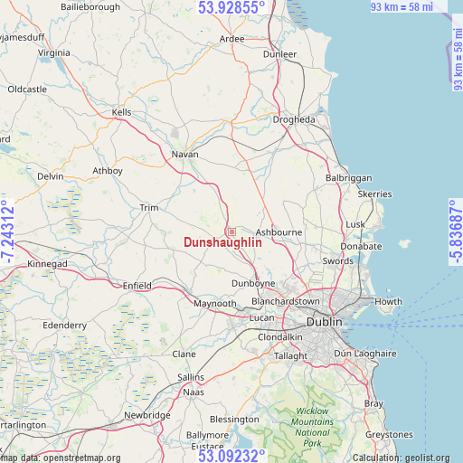
Dunshaughlin GPS coordinates[2]
53° 30' 45" North, 6° 32' 24" West
| Map corner | latitude | longitude |
|---|---|---|
| Upper-left | 53.92855°, | -7.24312° |
| Center: | 53.5125°, | -6.54° |
| Lower-right: | 53.09232°, | -5.83687° |
| Map W x H: | 93×93 km | = 57.8×57.8mi |
| max Lat: | 55.25° ⇑27.7% North |
| Dunshaughlin: | 53.5125° |
| min Lat: | ⇓72.3% South 51.52487° |
| min Long | Dunshaughlin | max Long |
| -10.26889° | -6.54° | -6.04944° |
| W 73.1%⇐ | ⇒26.9% E |
Elevation
Elevation of Dunshaughlin is 100 m = 328 ft, and this is 45.5 m = 149 ft above average elevation for this country.
| Max E: |
262 m = 860 ft | 12.9% |
| Dunshaughlin | 100 m 328 ft | |
| Avg. | 54.5 m = 179 ft | |
Min E: |
0 m = 0 ft | 87.1% |
See also: Ireland elevation on elevation.city.
Geographical zone
Dunshaughlin is located in North temperate zone (between Tropic of Cancer and the Arctic Circle). Distance of this North polar circle is 1451.1 km =901.7 mi to North.| Distance of | km | miles | from Dunshaughlin |
|---|---|---|---|
| North Pole | 4057 | 2520.9 | to North |
| Arctic Circle | 1451.1 | 901.7 | to North |
| Tropic Cancer | 3344.1 | 2077.9 | to South |
| Equator | 5950 | 3697.2 | to South |


Nearby cities:
15 places around Dunshaughlin: (largest is in red/bold)
• Ashbourne
9.4 km =5.8 mi,  90°
90°
• Blanchardstown
17.6 km =10.9 mi,  141°
141°
• Clonee
12.9 km =8 mi,  150°
150°
• Confey
15.2 km =9.4 mi,  167°
167°
• Dunboyne
11.3 km =7 mi,  157°
157°
• Hartstown
15.2 km =9.4 mi, 150°
• Kentstown
12.8 km =8 mi,  3°
3°
• Kilcock
15 km =9.3 mi,  215°
215°
• Kilmessan
9.4 km =5.8 mi,  303°
303°
• Leixlip
16.6 km =10.3 mi, 169°
• Maynooth
14.6 km =9.1 mi,  194°
194°
• Newtown Trim
16 km =9.9 mi,  287°
287°
• Ratoath
5.1 km =3.2 mi,  95°
95°
• Summerhill
13.6 km =8.5 mi,  253°
253°
• Trim
17.3 km =10.7 mi, 285°
Sources, notices
• [Note1] Compared only with cities in Ireland existing in our database
• [Src1] Map data: © OpenStreetMap contributors (CC-BY-SA)
• [Src2] Other city data from geonames.org with taken over terms of usage.
• [Src3] Geographical zone / Annual Mean Temperature by Robert A. Rohde @ Wikipedia
