Leixlip geodata
Leixlip (Leinster) is a populated place; located in Ireland in Europe/Dublin (GMT+1) time zone. With population of 15,452 people, there are 29 cities with bigger population in this country. Compared to other cities in Ireland, 61.7% of cities are located further ↓South; 74% of cities are located further ←West and 52.2% of cities have higher elevation than Leixlip. Note1


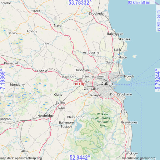
Leixlip GPS coordinates[2]
53° 21' 56.988" North, 6° 29' 44.016" West
| Map corner | latitude | longitude |
|---|---|---|
| Upper-left | 53.78332°, | -7.19869° |
| Center: | 53.36583°, | -6.49556° |
| Lower-right: | 52.9442°, | -5.79244° |
| Map W x H: | 93.3×93.3 km | = 58×58mi |
| max Lat: | 55.25° ⇑38.3% North |
| Leixlip: | 53.36583° |
| min Lat: | ⇓61.7% South 51.52487° |
| min Long | Leixlip | max Long |
| -10.26889° | -6.49556° | -6.04944° |
| W 74%⇐ | ⇒26% E |
Elevation
Elevation of Leixlip is 48 m = 157 ft, and this is 6.5 m = 21 ft below average elevation for this country.
| Max E: |
262 m = 860 ft | 52.2% |
| Avg. | 54.5 m = 179 ft | |
| Leixlip | 48 m = 157 ft | |
Min E: |
0 m = 0 ft | 47.8% |
See also: Ireland elevation on elevation.city.
Geographical zone
Leixlip is located in North temperate zone (between Tropic of Cancer and the Arctic Circle). Distance of this North polar circle is 1467.5 km =911.9 mi to North.| Distance of | km | miles | from Leixlip |
|---|---|---|---|
| North Pole | 4073.3 | 2531 | to North |
| Arctic Circle | 1467.5 | 911.9 | to North |
| Tropic Cancer | 3327.8 | 2067.8 | to South |
| Equator | 5933.7 | 3687 | to South |


Nearby cities:
15 places around Leixlip: (largest is in red/bold)
• Ballyfermot
9.7 km =6 mi,  105°
105°
• Blanchardstown
8.3 km =5.2 mi,  72°
72°
• Castleknock
8.8 km =5.5 mi,  83°
83°
• Celbridge
4.2 km =2.6 mi,  230°
230°
• Cherry Orchard
8.5 km =5.3 mi, 112°
• Clondalkin
8 km =5 mi,  125°
125°
• Clonee
6.1 km =3.8 mi,  33°
33°
• Confey
1.5 km =0.9 mi,  12°
12°
• Dunboyne
6.1 km =3.8 mi, 13°
• Hartstown
5.5 km =3.4 mi,  56°
56°
• Lucan
3.3 km =2.1 mi, 106°
• Maynooth
6.8 km =4.2 mi,  288°
288°
• Newcastle
7.2 km =4.5 mi,  183°
183°
• Palmerstown
8 km =5 mi,  102°
102°
• Rathcoole
9.4 km =5.8 mi,  170°
170°
Sources, notices
• [Note1] Compared only with cities in Ireland existing in our database
• [Src1] Map data: © OpenStreetMap contributors (CC-BY-SA)
• [Src2] Other city data from geonames.org with taken over terms of usage.
• [Src3] Geographical zone / Annual Mean Temperature by Robert A. Rohde @ Wikipedia
