Hartstown geodata
Hartstown (Leinster) is a populated place; located in Ireland in Europe/Dublin (GMT+1) time zone. With population of 5,882 people, there are 116 cities with bigger population in this country. Compared to other cities in Ireland, 66% of cities are located further ↓South; 76.9% of cities are located further ←West and 61.3% of cities have lower elevation than Hartstown. Note1


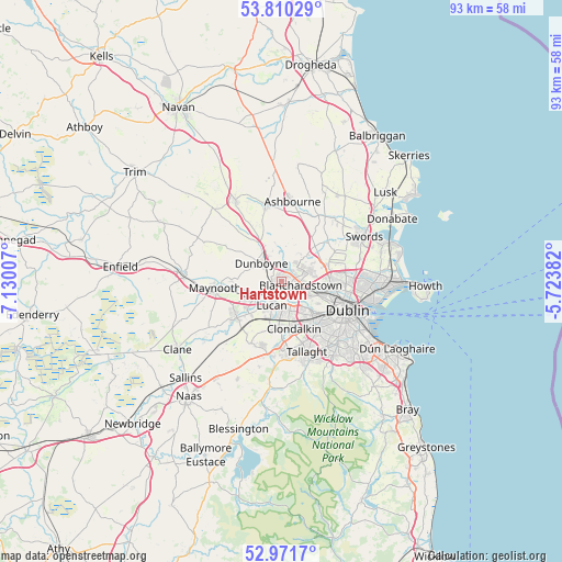
Hartstown GPS coordinates[2]
53° 23' 35.016" North, 6° 25' 36.984" West
| Map corner | latitude | longitude |
|---|---|---|
| Upper-left | 53.81029°, | -7.13007° |
| Center: | 53.39306°, | -6.42694° |
| Lower-right: | 52.9717°, | -5.72382° |
| Map W x H: | 93.2×93.2 km | = 57.9×57.9mi |
| max Lat: | 55.25° ⇑34% North |
| Hartstown: | 53.39306° |
| min Lat: | ⇓66% South 51.52487° |
| min Long | Hartstown | max Long |
| -10.26889° | -6.42694° | -6.04944° |
| W 76.9%⇐ | ⇒23.1% E |
Elevation
Elevation of Hartstown is 61 m = 200 ft, and this is 6.5 m = 21 ft above average elevation for this country.
| Max E: |
262 m = 860 ft | 38.7% |
| Hartstown | 61 m 200 ft | |
| Avg. | 54.5 m = 179 ft | |
Min E: |
0 m = 0 ft | 61.3% |
See also: Ireland elevation on elevation.city.
Geographical zone
Hartstown is located in North temperate zone (between Tropic of Cancer and the Arctic Circle). Distance of this North polar circle is 1464.4 km =909.9 mi to North.| Distance of | km | miles | from Hartstown |
|---|---|---|---|
| North Pole | 4070.3 | 2529.2 | to North |
| Arctic Circle | 1464.4 | 909.9 | to North |
| Tropic Cancer | 3330.8 | 2069.7 | to South |
| Equator | 5936.8 | 3689 | to South |


Nearby cities:
15 places around Hartstown: (largest is in red/bold)
• Ballyfermot
7.4 km =4.6 mi,  139°
139°
• Blanchardstown
3.5 km =2.2 mi,  99°
99°
• Cabra
9.3 km =5.8 mi,  108°
108°
• Castleknock
4.7 km =2.9 mi,  115°
115°
• Celbridge
9.7 km =6 mi,  233°
233°
• Chapelizod
7.5 km =4.7 mi,  131°
131°
• Cherry Orchard
7.1 km =4.4 mi,  152°
152°
• Clondalkin
7.9 km =4.9 mi,  165°
165°
• Clonee
2.4 km =1.5 mi,  331°
331°
• Confey
4.5 km =2.8 mi,  249°
249°
• Dunboyne
4.2 km =2.6 mi,  312°
312°
• Finglas
8.6 km =5.3 mi,  92°
92°
• Leixlip
5.5 km =3.4 mi,  236°
236°
• Lucan
4.2 km =2.6 mi,  199°
199°
• Palmerstown
5.8 km =3.6 mi, 145°
Sources, notices
• [Note1] Compared only with cities in Ireland existing in our database
• [Src1] Map data: © OpenStreetMap contributors (CC-BY-SA)
• [Src2] Other city data from geonames.org with taken over terms of usage.
• [Src3] Geographical zone / Annual Mean Temperature by Robert A. Rohde @ Wikipedia
