Maynooth geodata
Maynooth (Leinster) is a populated place; located in Ireland in Europe/Dublin (GMT+1) time zone. With population of 12,510 people, there are 42 cities with bigger population in this country. Compared to other cities in Ireland, 63.9% of cities are located further ↓South; 71% of cities are located further ←West and 55.4% of cities have lower elevation than Maynooth. Note1


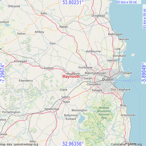
Maynooth GPS coordinates[2]
53° 23' 6" North, 6° 35' 36.996" West
| Map corner | latitude | longitude |
|---|---|---|
| Upper-left | 53.80231°, | -7.29674° |
| Center: | 53.385°, | -6.59361° |
| Lower-right: | 52.96356°, | -5.89049° |
| Map W x H: | 93.3×93.3 km | = 58×58mi |
| max Lat: | 55.25° ⇑36.1% North |
| Maynooth: | 53.385° |
| min Lat: | ⇓63.9% South 51.52487° |
| min Long | Maynooth | max Long |
| -10.26889° | -6.59361° | -6.04944° |
| W 71%⇐ | ⇒29% E |
Elevation
Elevation of Maynooth is 56 m = 184 ft, and this is 1.5 m = 5 ft above average elevation for this country.
| Max E: |
262 m = 860 ft | 44.6% |
| Maynooth | 56 m 184 ft | |
| Avg. | 54.5 m = 179 ft | |
Min E: |
0 m = 0 ft | 55.4% |
See also: Ireland elevation on elevation.city.
Geographical zone
Maynooth is located in North temperate zone (between Tropic of Cancer and the Arctic Circle). Distance of this North polar circle is 1465.3 km =910.5 mi to North.| Distance of | km | miles | from Maynooth |
|---|---|---|---|
| North Pole | 4071.2 | 2529.7 | to North |
| Arctic Circle | 1465.3 | 910.5 | to North |
| Tropic Cancer | 3329.9 | 2069.1 | to South |
| Equator | 5935.9 | 3688.4 | to South |


Nearby cities:
15 places around Maynooth: (largest is in red/bold)
• Blanchardstown
14.5 km =9 mi,  88°
88°
• Celbridge
5.8 km =3.6 mi,  145°
145°
• Clane
12.2 km =7.6 mi,  211°
211°
• Clonee
10.3 km =6.4 mi,  73°
73°
• Confey
6.9 km =4.3 mi,  95°
95°
• Dunboyne
8.8 km =5.5 mi,  64°
64°
• Dunshaughlin
14.6 km =9.1 mi,  14°
14°
• Hartstown
11.1 km =6.9 mi, 85°
• Kilcock
5.5 km =3.4 mi,  290°
290°
• Leixlip
6.8 km =4.2 mi,  108°
108°
• Lucan
10.1 km =6.3 mi, 107°
• Newcastle
11.1 km =6.9 mi, 146°
• Rathcoole
13.9 km =8.6 mi,  144°
144°
• Straffan
8 km =5 mi,  189°
189°
• Summerhill
13.9 km =8.6 mi,  317°
317°
Sources, notices
• [Note1] Compared only with cities in Ireland existing in our database
• [Src1] Map data: © OpenStreetMap contributors (CC-BY-SA)
• [Src2] Other city data from geonames.org with taken over terms of usage.
• [Src3] Geographical zone / Annual Mean Temperature by Robert A. Rohde @ Wikipedia
