Kilcock geodata
Kilcock (Leinster) is a populated place; located in Ireland in Europe/Dublin (GMT+1) time zone. With population of 5,533 people, there are 123 cities with bigger population in this country. Compared to other cities in Ireland, 67.4% of cities are located further ↓South; 69.3% of cities are located further ←West and 68.3% of cities have lower elevation than Kilcock. Note1


Kilcock GPS coordinates[2]
53° 24' 7.992" North, 6° 40' 14.988" West
| Map corner | latitude | longitude |
|---|---|---|
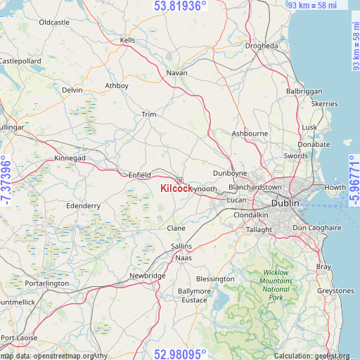
| Upper-left | 53.81936°, | -7.37396° |
| Center: | 53.40222°, | -6.67083° |
| Lower-right: | 52.98095°, | -5.96771° |
| Map W x H: | 93.2×93.2 km | = 57.9×57.9mi |
| max Lat: | 55.25° ⇑32.6% North |
| Kilcock: | 53.40222° |
| min Lat: | ⇓67.4% South 51.52487° |
| min Long | Kilcock | max Long |
| -10.26889° | -6.67083° | -6.04944° |
| W 69.3%⇐ | ⇒30.7% E |
Elevation
Elevation of Kilcock is 68 m = 223 ft, and this is 13.5 m = 44 ft above average elevation for this country.
| Max E: |
262 m = 860 ft | 31.7% |
| Kilcock | 68 m 223 ft | |
| Avg. | 54.5 m = 179 ft | |
Min E: |
0 m = 0 ft | 68.3% |
See also: Ireland elevation on elevation.city.
Geographical zone
Kilcock is located in North temperate zone (between Tropic of Cancer and the Arctic Circle). Distance of this North polar circle is 1463.4 km =909.3 mi to North.| Distance of | km | miles | from Kilcock |
|---|---|---|---|
| North Pole | 4069.3 | 2528.5 | to North |
| Arctic Circle | 1463.4 | 909.3 | to North |
| Tropic Cancer | 3331.9 | 2070.3 | to South |
| Equator | 5937.8 | 3689.6 | to South |


Nearby cities:
15 places around Kilcock: (largest is in red/bold)
• Blackwood
15.6 km =9.7 mi,  218°
218°
• Celbridge
10.8 km =6.7 mi,  128°
128°
• Clane
12.4 km =7.7 mi,  185°
185°
• Clonee
15.1 km =9.4 mi,  85°
85°
• Confey
12.2 km =7.6 mi,  102°
102°
• Dunboyne
13.2 km =8.2 mi,  81°
81°
• Dunshaughlin
15 km =9.3 mi,  35°
35°
• Enfield
10.8 km =6.7 mi,  277°
277°
• Johnstown Bridge
12.5 km =7.8 mi,  270°
270°
• Leixlip
12.3 km =7.6 mi,  109°
109°
• Lucan
15.6 km =9.7 mi, 108°
• Maynooth
5.5 km =3.4 mi, 110°
• Prosperous
13.6 km =8.5 mi,  203°
203°
• Straffan
10.5 km =6.5 mi,  158°
158°
• Summerhill
9.4 km =5.8 mi,  332°
332°
Sources, notices
• [Note1] Compared only with cities in Ireland existing in our database
• [Src1] Map data: © OpenStreetMap contributors (CC-BY-SA)
• [Src2] Other city data from geonames.org with taken over terms of usage.
• [Src3] Geographical zone / Annual Mean Temperature by Robert A. Rohde @ Wikipedia
