Summerhill geodata
Summerhill (Leinster) is a populated place; located in Ireland in Europe/Dublin (GMT+1) time zone. With population of 832 people, there are 387 cities with bigger population in this country. Compared to other cities in Ireland, 70.8% of cities are located further ↓South; 67.6% of cities are located further ←West and 75.3% of cities have lower elevation than Summerhill. Note1


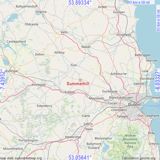
Summerhill GPS coordinates[2]
53° 28' 36.984" North, 6° 44' 11.004" West
| Map corner | latitude | longitude |
|---|---|---|
| Upper-left | 53.89334°, | -7.43952° |
| Center: | 53.47694°, | -6.73639° |
| Lower-right: | 53.05641°, | -6.03327° |
| Map W x H: | 93.1×93.1 km | = 57.8×57.8mi |
| max Lat: | 55.25° ⇑29.2% North |
| Summerhill: | 53.47694° |
| min Lat: | ⇓70.8% South 51.52487° |
| min Long | Summerhill | max Long |
| -10.26889° | -6.73639° | -6.04944° |
| W 67.6%⇐ | ⇒32.4% E |
Elevation
Elevation of Summerhill is 81 m = 266 ft, and this is 26.5 m = 87 ft above average elevation for this country.
| Max E: |
262 m = 860 ft | 24.7% |
| Summerhill | 81 m 266 ft | |
| Avg. | 54.5 m = 179 ft | |
Min E: |
0 m = 0 ft | 75.3% |
See also: Ireland elevation on elevation.city.
Geographical zone
Summerhill is located in North temperate zone (between Tropic of Cancer and the Arctic Circle). Distance of this North polar circle is 1455.1 km =904.2 mi to North.| Distance of | km | miles | from Summerhill |
|---|---|---|---|
| North Pole | 4061 | 2523.4 | to North |
| Arctic Circle | 1455.1 | 904.2 | to North |
| Tropic Cancer | 3340.2 | 2075.5 | to South |
| Equator | 5946.1 | 3694.7 | to South |


Nearby cities:
15 places around Summerhill: (largest is in red/bold)
• Ballivor
16.1 km =10 mi,  292°
292°
• Celbridge
19.7 km =12.2 mi,  139°
139°
• Confey
19.6 km =12.2 mi,  123°
123°
• Dunboyne
18.5 km =11.5 mi,  110°
110°
• Dunshaughlin
13.6 km =8.5 mi,  73°
73°
• Enfield
9.4 km =5.8 mi,  222°
222°
• Johnstown Bridge
11.5 km =7.1 mi, 224°
• Kilcock
9.4 km =5.8 mi,  152°
152°
• Kildalkey
15.2 km =9.4 mi,  313°
313°
• Kilmessan
10.4 km =6.5 mi,  29°
29°
• Longwood
12.5 km =7.8 mi,  258°
258°
• Maynooth
13.9 km =8.6 mi, 137°
• Newtown Trim
9.1 km =5.7 mi,  345°
345°
• Ratoath
18.4 km =11.4 mi,  79°
79°
• Trim
9.4 km =5.8 mi,  337°
337°
Sources, notices
• [Note1] Compared only with cities in Ireland existing in our database
• [Src1] Map data: © OpenStreetMap contributors (CC-BY-SA)
• [Src2] Other city data from geonames.org with taken over terms of usage.
• [Src3] Geographical zone / Annual Mean Temperature by Robert A. Rohde @ Wikipedia
