Grenagh geodata
Grenagh (Munster) is a populated place; located in Ireland in Europe/Dublin (GMT+1) time zone. With population of 562 people, there are 496 cities with bigger population in this country. Compared to other cities in Ireland, 92.2% of cities are located further ↑North; 78.9% of cities are located further →East and 96.8% of cities have lower elevation than Grenagh. Note1


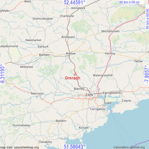
Grenagh GPS coordinates[2]
52° 0' 54.936" North, 8° 36' 31.752" West
| Map corner | latitude | longitude |
|---|---|---|
| Upper-left | 52.44591°, | -9.31195° |
| Center: | 52.01526°, | -8.60882° |
| Lower-right: | 51.58043°, | -7.9057° |
| Map W x H: | 96.2×96.2 km | = 59.8×59.8mi |
| max Lat: | 55.25° ⇑92.2% North |
| Grenagh: | 52.01526° |
| min Lat: | ⇓7.8% South 51.52487° |
| min Long | Grenagh | max Long |
| -10.26889° | -8.60882° | -6.04944° |
| W 21.1%⇐ | ⇒78.9% E |
Elevation
Elevation of Grenagh is 139 m = 456 ft, and this is 84.5 m = 277 ft above average elevation for this country.
| Max E: |
262 m = 860 ft | 3.2% |
| Grenagh | 139 m 456 ft | |
| Avg. | 54.5 m = 179 ft | |
Min E: |
0 m = 0 ft | 96.8% |
See also: Ireland elevation on elevation.city.
Geographical zone
Grenagh is located in North temperate zone (between Tropic of Cancer and the Arctic Circle). Distance of this North polar circle is 1617.6 km =1005.1 mi to North.| Distance of | km | miles | from Grenagh |
|---|---|---|---|
| North Pole | 4223.5 | 2624.4 | to North |
| Arctic Circle | 1617.6 | 1005.1 | to North |
| Tropic Cancer | 3177.6 | 1974.5 | to South |
| Equator | 5783.6 | 3593.8 | to South |


Nearby cities:
15 places around Grenagh: (largest is in red/bold)
• Ballygarvan
23.7 km =14.7 mi,  154°
154°
• Blarney
9.6 km =6 mi,  162°
162°
• Buttevant
24.6 km =15.3 mi,  350°
350°
• Cork
16.1 km =10 mi,  144°
144°
• Courtbrack
6 km =3.7 mi,  205°
205°
• Doneraile
22.5 km =14 mi,  4°
4°
• Drommahane
11.4 km =7.1 mi,  330°
330°
• Killumney
16.1 km =10 mi,  189°
189°
• Mallow
13.2 km =8.2 mi, 352°
• Passage West
24 km =14.9 mi,  130°
130°
• Rathard
20.6 km =12.8 mi, 205°
• Rathcormac
23.4 km =14.5 mi,  72°
72°
• Tower
9.9 km =6.2 mi,  179°
179°
• Watergrasshill
18.1 km =11.2 mi,  91°
91°
• Whitechurch
7.5 km =4.7 mi,  120°
120°
Sources, notices
• [Note1] Compared only with cities in Ireland existing in our database
• [Src1] Map data: © OpenStreetMap contributors (CC-BY-SA)
• [Src2] Other city data from geonames.org with taken over terms of usage.
• [Src3] Geographical zone / Annual Mean Temperature by Robert A. Rohde @ Wikipedia
