Whitechurch geodata
Whitechurch (Munster) is a populated place; located in Ireland in Europe/Dublin (GMT+1) time zone. With population of 573 people, there are 493 cities with bigger population in this country. Compared to other cities in Ireland, 92.6% of cities are located further ↑North; 75.5% of cities are located further →East and 99.2% of cities have lower elevation than Whitechurch. Note1


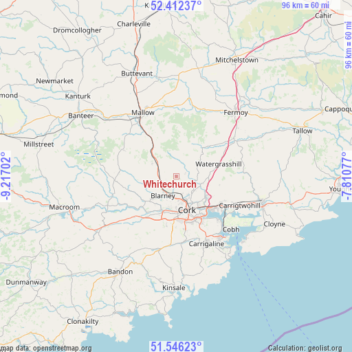
Whitechurch GPS coordinates[2]
51° 58' 53.004" North, 8° 30' 50.004" West
| Map corner | latitude | longitude |
|---|---|---|
| Upper-left | 52.41237°, | -9.21702° |
| Center: | 51.98139°, | -8.51389° |
| Lower-right: | 51.54623°, | -7.81077° |
| Map W x H: | 96.3×96.3 km | = 59.8×59.8mi |
| max Lat: | 55.25° ⇑92.6% North |
| Whitechurch: | 51.98139° |
| min Lat: | ⇓7.4% South 51.52487° |
| min Long | Whitechurch | max Long |
| -10.26889° | -8.51389° | -6.04944° |
| W 24.5%⇐ | ⇒75.5% E |
Elevation
Elevation of Whitechurch is 180 m = 591 ft, and this is 125.5 m = 412 ft above average elevation for this country.
| Max E: |
262 m = 860 ft | 0.8% |
| Whitechurch | 180 m 591 ft | |
| Avg. | 54.5 m = 179 ft | |
Min E: |
0 m = 0 ft | 99.2% |
See also: Ireland elevation on elevation.city.
Geographical zone
Whitechurch is located in North temperate zone (between Tropic of Cancer and the Arctic Circle). Distance of this North polar circle is 1621.4 km =1007.5 mi to North.| Distance of | km | miles | from Whitechurch |
|---|---|---|---|
| North Pole | 4227.3 | 2626.7 | to North |
| Arctic Circle | 1621.4 | 1007.5 | to North |
| Tropic Cancer | 3173.9 | 1972.2 | to South |
| Equator | 5779.8 | 3591.4 | to South |


Nearby cities:
15 places around Whitechurch: (largest is in red/bold)
• Ballygarvan
18.1 km =11.2 mi,  168°
168°
• Blarney
6.5 km =4 mi,  214°
214°
• Carrigaline
20.5 km =12.7 mi,  157°
157°
• Carrigtwohill
19 km =11.8 mi,  115°
115°
• Cobh
20.9 km =13 mi,  134°
134°
• Cork
9.7 km =6 mi, 162°
• Courtbrack
9.2 km =5.7 mi,  259°
259°
• Drommahane
18.3 km =11.4 mi,  318°
318°
• Grenagh
7.5 km =4.7 mi,  300°
300°
• Killumney
15.2 km =9.4 mi,  217°
217°
• Mallow
18.8 km =11.7 mi,  334°
334°
• Passage West
16.7 km =10.4 mi,  135°
135°
• Rathcormac
19.1 km =11.9 mi,  56°
56°
• Tower
8.9 km =5.5 mi,  226°
226°
• Watergrasshill
12.1 km =7.5 mi,  73°
73°
Sources, notices
• [Note1] Compared only with cities in Ireland existing in our database
• [Src1] Map data: © OpenStreetMap contributors (CC-BY-SA)
• [Src2] Other city data from geonames.org with taken over terms of usage.
• [Src3] Geographical zone / Annual Mean Temperature by Robert A. Rohde @ Wikipedia
