Courtbrack geodata
Courtbrack (Munster) is a seat of a second-order administrative division; located in Ireland in Europe/Dublin (GMT+1) time zone. In our database, there are 526 cities with bigger population. Compared to other cities in Ireland, 92.8% of cities are located further ↑North; 79.9% of cities are located further →East and 80.5% of cities have lower elevation than Courtbrack. Note1


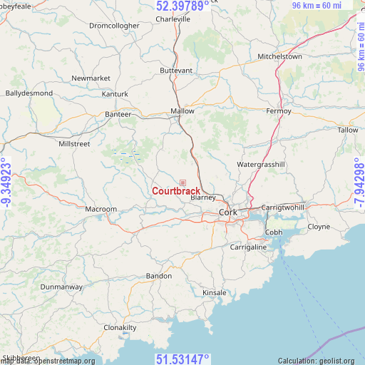
Courtbrack GPS coordinates[2]
51° 58' 0.372" North, 8° 38' 45.996" West
| Map corner | latitude | longitude |
|---|---|---|
| Upper-left | 52.39789°, | -9.34923° |
| Center: | 51.96677°, | -8.64611° |
| Lower-right: | 51.53147°, | -7.94298° |
| Map W x H: | 96.3×96.3 km | = 59.8×59.8mi |
| max Lat: | 55.25° ⇑92.8% North |
| Courtbrack: | 51.96677° |
| min Lat: | ⇓7.2% South 51.52487° |
| min Long | Courtbrack | max Long |
| -10.26889° | -8.64611° | -6.04944° |
| W 20.1%⇐ | ⇒79.9% E |
Elevation
Elevation of Courtbrack is 89 m = 292 ft, and this is 34.5 m = 113 ft above average elevation for this country.
| Max E: |
262 m = 860 ft | 19.5% |
| Courtbrack | 89 m 292 ft | |
| Avg. | 54.5 m = 179 ft | |
Min E: |
0 m = 0 ft | 80.5% |
See also: Ireland elevation on elevation.city.
Geographical zone
Courtbrack is located in North temperate zone (between Tropic of Cancer and the Arctic Circle). Distance of this North polar circle is 1623 km =1008.5 mi to North.| Distance of | km | miles | from Courtbrack |
|---|---|---|---|
| North Pole | 4228.9 | 2627.7 | to North |
| Arctic Circle | 1623 | 1008.5 | to North |
| Tropic Cancer | 3172.2 | 1971.1 | to South |
| Equator | 5778.2 | 3590.4 | to South |


Nearby cities:
15 places around Courtbrack: (largest is in red/bold)
• Ballygarvan
20.5 km =12.7 mi,  141°
141°
• Blarney
6.6 km =4.1 mi,  124°
124°
• Cork
14.3 km =8.9 mi, 122°
• Drommahane
15.6 km =9.7 mi,  348°
348°
• Grenagh
6 km =3.7 mi,  25°
25°
• Innishannon
22.4 km =13.9 mi,  181°
181°
• Killumney
10.5 km =6.5 mi, 180°
• Macroom
23.2 km =14.4 mi,  253°
253°
• Mallow
18.5 km =11.5 mi,  2°
2°
• Passage West
23.1 km =14.4 mi, 116°
• Rathard
14.6 km =9.1 mi,  205°
205°
• Riverstick
24 km =14.9 mi,  154°
154°
• Tower
5.3 km =3.3 mi, 149°
• Watergrasshill
21.3 km =13.2 mi,  76°
76°
• Whitechurch
9.2 km =5.7 mi, 79°
Sources, notices
• [Note1] Compared only with cities in Ireland existing in our database
• [Src1] Map data: © OpenStreetMap contributors (CC-BY-SA)
• [Src2] Other city data from geonames.org with taken over terms of usage.
• [Src3] Geographical zone / Annual Mean Temperature by Robert A. Rohde @ Wikipedia
