Lucan geodata
Lucan (Leinster) is a populated place; located in Ireland in Europe/Dublin (GMT+1) time zone. With population of 15,269 people, there are 31 cities with bigger population in this country. Compared to other cities in Ireland, 61.3% of cities are located further ↓South; 76.3% of cities are located further ←West and 71.9% of cities have higher elevation than Lucan. Note1


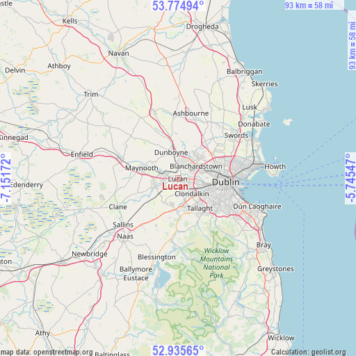
Lucan GPS coordinates[2]
53° 21' 26.496" North, 6° 26' 54.924" West
| Map corner | latitude | longitude |
|---|---|---|
| Upper-left | 53.77494°, | -7.15172° |
| Center: | 53.35736°, | -6.44859° |
| Lower-right: | 52.93565°, | -5.74547° |
| Map W x H: | 93.3×93.3 km | = 58×58mi |
| max Lat: | 55.25° ⇑38.7% North |
| Lucan: | 53.35736° |
| min Lat: | ⇓61.3% South 51.52487° |
| min Long | Lucan | max Long |
| -10.26889° | -6.44859° | -6.04944° |
| W 76.3%⇐ | ⇒23.7% E |
Elevation
Elevation of Lucan is 25 m = 82 ft, and this is 29.5 m = 97 ft below average elevation for this country.
| Max E: |
262 m = 860 ft | 71.9% |
| Avg. | 54.5 m = 179 ft | |
| Lucan | 25 m = 82 ft | |
Min E: |
0 m = 0 ft | 28.1% |
See also: Ireland elevation on elevation.city.
Geographical zone
Lucan is located in North temperate zone (between Tropic of Cancer and the Arctic Circle). Distance of this North polar circle is 1468.4 km =912.4 mi to North.| Distance of | km | miles | from Lucan |
|---|---|---|---|
| North Pole | 4074.3 | 2531.7 | to North |
| Arctic Circle | 1468.4 | 912.4 | to North |
| Tropic Cancer | 3326.9 | 2067.2 | to South |
| Equator | 5932.8 | 3686.5 | to South |


Nearby cities:
15 places around Lucan: (largest is in red/bold)
• Ballyfermot
6.4 km =4 mi,  104°
104°
• Blanchardstown
5.9 km =3.7 mi,  54°
54°
• Castleknock
6 km =3.7 mi,  71°
71°
• Celbridge
6.6 km =4.1 mi,  254°
254°
• Chapelizod
7.1 km =4.4 mi, 98°
• Cherry Orchard
5.3 km =3.3 mi,  116°
116°
• Clondalkin
5 km =3.1 mi,  137°
137°
• Clonee
6 km =3.7 mi,  2°
2°
• Confey
3.7 km =2.3 mi,  311°
311°
• Dunboyne
7.1 km =4.4 mi,  346°
346°
• Hartstown
4.2 km =2.6 mi,  19°
19°
• Leixlip
3.3 km =2.1 mi,  286°
286°
• Newcastle
7.2 km =4.5 mi,  209°
209°
• Palmerstown
4.8 km =3 mi, 99°
• Rathcoole
8.4 km =5.2 mi,  190°
190°
Sources, notices
• [Note1] Compared only with cities in Ireland existing in our database
• [Src1] Map data: © OpenStreetMap contributors (CC-BY-SA)
• [Src2] Other city data from geonames.org with taken over terms of usage.
• [Src3] Geographical zone / Annual Mean Temperature by Robert A. Rohde @ Wikipedia
