Carlingford geodata
Carlingford (Leinster) is a populated place; located in Ireland in Europe/Dublin (GMT+1) time zone. With population of 1,045 people, there are 341 cities with bigger population in this country. Compared to other cities in Ireland, 88.2% of cities are located further ↓South; 92% of cities are located further ←West and 86.3% of cities have higher elevation than Carlingford. Note1


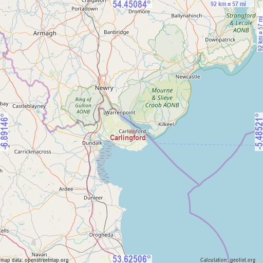
Carlingford GPS coordinates[2]
54° 2' 24" North, 6° 11' 17.988" West
| Map corner | latitude | longitude |
|---|---|---|
| Upper-left | 54.45084°, | -6.89146° |
| Center: | 54.04°, | -6.18833° |
| Lower-right: | 53.62506°, | -5.48521° |
| Map W x H: | 91.8×91.8 km | = 57×57mi |
| max Lat: | 55.25° ⇑11.8% North |
| Carlingford: | 54.04° |
| min Lat: | ⇓88.2% South 51.52487° |
| min Long | Carlingford | max Long |
| -10.26889° | -6.18833° | -6.04944° |
| W 92%⇐ | ⇒8% E |
Elevation
Elevation of Carlingford is 12 m = 39 ft, and this is 42.5 m = 139 ft below average elevation for this country.
| Max E: |
262 m = 860 ft | 86.3% |
| Avg. | 54.5 m = 179 ft | |
| Carlingford | 12 m = 39 ft | |
Min E: |
0 m = 0 ft | 13.7% |
See also: Ireland elevation on elevation.city.
Geographical zone
Carlingford is located in North temperate zone (between Tropic of Cancer and the Arctic Circle). Distance of this North polar circle is 1392.5 km =865.3 mi to North.| Distance of | km | miles | from Carlingford |
|---|---|---|---|
| North Pole | 3998.4 | 2484.5 | to North |
| Arctic Circle | 1392.5 | 865.3 | to North |
| Tropic Cancer | 3402.8 | 2114.4 | to South |
| Equator | 6008.7 | 3733.6 | to South |


Nearby cities:
15 places around Carlingford: (largest is in red/bold)
• Ardee
30.5 km =19 mi,  228°
228°
• Blackrock
14.3 km =8.9 mi, 233°
• Carrickmacross
35.5 km =22.1 mi,  257°
257°
• Castlebellingham
20.3 km =12.6 mi,  220°
220°
• Castleblayney
36.6 km =22.7 mi,  283°
283°
• Clogherhead
27.6 km =17.1 mi,  186°
186°
• Collon
34.8 km =21.6 mi,  214°
214°
• Dromiskin
19 km =11.8 mi, 227°
• Dundalk
15.6 km =9.7 mi,  253°
253°
• Dunleer
26.5 km =16.5 mi, 210°
• Knockbridge
20.8 km =12.9 mi, 249°
• Louth
25.2 km =15.7 mi, 246°
• Omeath
7.2 km =4.5 mi,  320°
320°
• Tallanstown
26.8 km =16.7 mi,  240°
240°
• Termonfeckin
31.2 km =19.4 mi, 189°
Sources, notices
• [Note1] Compared only with cities in Ireland existing in our database
• [Src1] Map data: © OpenStreetMap contributors (CC-BY-SA)
• [Src2] Other city data from geonames.org with taken over terms of usage.
• [Src3] Geographical zone / Annual Mean Temperature by Robert A. Rohde @ Wikipedia
