Tallanstown geodata
Tallanstown (Leinster) is a populated place; located in Ireland in Europe/Dublin (GMT+1) time zone. With population of 673 people, there are 442 cities with bigger population in this country. Compared to other cities in Ireland, 85.2% of cities are located further ↓South; 72.1% of cities are located further ←West and 75% of cities have higher elevation than Tallanstown. Note1


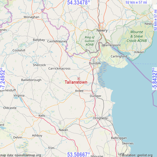
Tallanstown GPS coordinates[2]
53° 55' 22.008" North, 6° 32' 47.004" West
| Map corner | latitude | longitude |
|---|---|---|
| Upper-left | 54.33478°, | -7.24952° |
| Center: | 53.92278°, | -6.54639° |
| Lower-right: | 53.50667°, | -5.84327° |
| Map W x H: | 92.1×92.1 km | = 57.2×57.2mi |
| max Lat: | 55.25° ⇑14.8% North |
| Tallanstown: | 53.92278° |
| min Lat: | ⇓85.2% South 51.52487° |
| min Long | Tallanstown | max Long |
| -10.26889° | -6.54639° | -6.04944° |
| W 72.1%⇐ | ⇒27.9% E |
Elevation
Elevation of Tallanstown is 21 m = 69 ft, and this is 33.5 m = 110 ft below average elevation for this country.
| Max E: |
262 m = 860 ft | 75% |
| Avg. | 54.5 m = 179 ft | |
| Tallanstown | 21 m = 69 ft | |
Min E: |
0 m = 0 ft | 25% |
See also: Ireland elevation on elevation.city.
Geographical zone
Tallanstown is located in North temperate zone (between Tropic of Cancer and the Arctic Circle). Distance of this North polar circle is 1405.5 km =873.3 mi to North.| Distance of | km | miles | from Tallanstown |
|---|---|---|---|
| North Pole | 4011.4 | 2492.6 | to North |
| Arctic Circle | 1405.5 | 873.3 | to North |
| Tropic Cancer | 3389.7 | 2106.3 | to South |
| Equator | 5995.7 | 3725.6 | to South |


Nearby cities:
15 places around Tallanstown: (largest is in red/bold)
• Ardee
7 km =4.3 mi,  176°
176°
• Blackrock
12.7 km =7.9 mi,  68°
68°
• Carrickmacross
12.6 km =7.8 mi,  296°
296°
• Castlebellingham
10.5 km =6.5 mi,  103°
103°
• Clogherhead
24.8 km =15.4 mi,  125°
125°
• Collon
16.2 km =10.1 mi,  166°
166°
• Dromiskin
9.4 km =5.8 mi,  88°
88°
• Dundalk
12.1 km =7.5 mi,  44°
44°
• Dunleer
13.9 km =8.6 mi, 134°
• Kingscourt
17.1 km =10.6 mi,  264°
264°
• Knockbridge
6.9 km =4.3 mi, 35°
• Louth
2.9 km =1.8 mi,  6°
6°
• Shercock
24.7 km =15.3 mi,  290°
290°
• Slane
23.7 km =14.7 mi, 179°
• Tullyallen
22.3 km =13.9 mi,  158°
158°
Sources, notices
• [Note1] Compared only with cities in Ireland existing in our database
• [Src1] Map data: © OpenStreetMap contributors (CC-BY-SA)
• [Src2] Other city data from geonames.org with taken over terms of usage.
• [Src3] Geographical zone / Annual Mean Temperature by Robert A. Rohde @ Wikipedia
