Castleblayney geodata
Castleblayney (Ulster) is a populated place; located in Ireland in Europe/Dublin (GMT+1) time zone. With population of 3,006 people, there are 186 cities with bigger population in this country. Compared to other cities in Ireland, 90.1% of cities are located further ↓South; 67.7% of cities are located further ←West and 94.1% of cities have lower elevation than Castleblayney. Note1


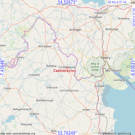
Castleblayney GPS coordinates[2]
54° 7' 0.012" North, 6° 43' 59.988" West
| Map corner | latitude | longitude |
|---|---|---|
| Upper-left | 54.52675°, | -7.43646° |
| Center: | 54.11667°, | -6.73333° |
| Lower-right: | 53.70249°, | -6.03021° |
| Map W x H: | 91.6×91.6 km | = 56.9×56.9mi |
| max Lat: | 55.25° ⇑9.9% North |
| Castleblayney: | 54.11667° |
| min Lat: | ⇓90.1% South 51.52487° |
| min Long | Castleblayney | max Long |
| -10.26889° | -6.73333° | -6.04944° |
| W 67.7%⇐ | ⇒32.3% E |
Elevation
Elevation of Castleblayney is 117 m = 384 ft, and this is 62.5 m = 205 ft above average elevation for this country.
| Max E: |
262 m = 860 ft | 5.9% |
| Castleblayney | 117 m 384 ft | |
| Avg. | 54.5 m = 179 ft | |
Min E: |
0 m = 0 ft | 94.1% |
See also: Ireland elevation on elevation.city.
Geographical zone
Castleblayney is located in North temperate zone (between Tropic of Cancer and the Arctic Circle). Distance of this North polar circle is 1384 km =860 mi to North.| Distance of | km | miles | from Castleblayney |
|---|---|---|---|
| North Pole | 3989.9 | 2479.2 | to North |
| Arctic Circle | 1384 | 860 | to North |
| Tropic Cancer | 3411.3 | 2119.7 | to South |
| Equator | 6017.2 | 3738.9 | to South |


Nearby cities:
15 places around Castleblayney: (largest is in red/bold)
• Ardee
31.2 km =19.4 mi,  156°
156°
• Bailieborough
27 km =16.8 mi,  214°
214°
• Blackrock
29.4 km =18.3 mi,  125°
125°
• Carrickmacross
16 km =9.9 mi,  176°
176°
• Cootehill
23.3 km =14.5 mi,  257°
257°
• Dromiskin
30.3 km =18.8 mi, 134°
• Dundalk
24.4 km =15.2 mi,  122°
122°
• Emyvale
28.9 km =18 mi,  329°
329°
• Kingscourt
23.7 km =14.7 mi,  191°
191°
• Knockbridge
22.7 km =14.1 mi, 134°
• Louth
22.5 km =14 mi,  146°
146°
• Monaghan
21.2 km =13.2 mi,  314°
314°
• Omeath
31 km =19.3 mi,  95°
95°
• Shercock
16.9 km =10.5 mi,  219°
219°
• Tallanstown
24.8 km =15.4 mi, 150°
Sources, notices
• [Note1] Compared only with cities in Ireland existing in our database
• [Src1] Map data: © OpenStreetMap contributors (CC-BY-SA)
• [Src2] Other city data from geonames.org with taken over terms of usage.
• [Src3] Geographical zone / Annual Mean Temperature by Robert A. Rohde @ Wikipedia
