Cloughjordan geodata
Cloughjordan (Munster) is a populated place; located in Ireland in Europe/Dublin (GMT+1) time zone. With population of 511 people, there are 518 cities with bigger population in this country. Compared to other cities in Ireland, 63.4% of cities are located further ↑North; 63.4% of cities are located further →East and 83.5% of cities have lower elevation than Cloughjordan. Note1


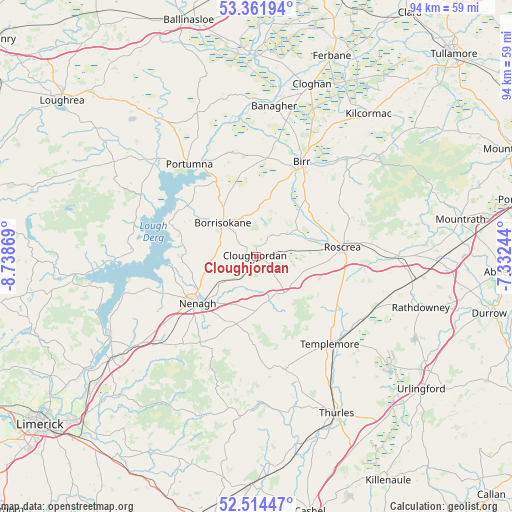
Cloughjordan GPS coordinates[2]
52° 56' 25.008" North, 8° 2' 8.016" West
| Map corner | latitude | longitude |
|---|---|---|
| Upper-left | 53.36194°, | -8.73869° |
| Center: | 52.94028°, | -8.03556° |
| Lower-right: | 52.51447°, | -7.33244° |
| Map W x H: | 94.2×94.2 km | = 58.5×58.5mi |
| max Lat: | 55.25° ⇑63.4% North |
| Cloughjordan: | 52.94028° |
| min Lat: | ⇓36.6% South 51.52487° |
| min Long | Cloughjordan | max Long |
| -10.26889° | -8.03556° | -6.04944° |
| W 36.6%⇐ | ⇒63.4% E |
Elevation
Elevation of Cloughjordan is 93 m = 305 ft, and this is 38.5 m = 126 ft above average elevation for this country.
| Max E: |
262 m = 860 ft | 16.5% |
| Cloughjordan | 93 m 305 ft | |
| Avg. | 54.5 m = 179 ft | |
Min E: |
0 m = 0 ft | 83.5% |
See also: Ireland elevation on elevation.city.
Geographical zone
Cloughjordan is located in North temperate zone (between Tropic of Cancer and the Arctic Circle). Distance of this North polar circle is 1514.8 km =941.3 mi to North.| Distance of | km | miles | from Cloughjordan |
|---|---|---|---|
| North Pole | 4120.7 | 2560.5 | to North |
| Arctic Circle | 1514.8 | 941.3 | to North |
| Tropic Cancer | 3280.5 | 2038.4 | to South |
| Equator | 5886.4 | 3657.6 | to South |


Nearby cities:
15 places around Cloughjordan: (largest is in red/bold)
• Ballina
30.6 km =19 mi,  241°
241°
• Banagher
27.8 km =17.3 mi,  6°
6°
• Birr
18.7 km =11.6 mi,  25°
25°
• Borrisokane
8.7 km =5.4 mi,  314°
314°
• Borrisoleigh
21.6 km =13.4 mi,  165°
165°
• Cloghan
32.9 km =20.4 mi,  17°
17°
• Killaloe
31.2 km =19.4 mi, 241°
• Nenagh
13.9 km =8.6 mi,  231°
231°
• Nenagh Bridge
12.6 km =7.8 mi, 238°
• Portumna
20.6 km =12.8 mi,  323°
323°
• Rathdowney
32 km =19.9 mi,  107°
107°
• Roscrea
15.7 km =9.8 mi,  85°
85°
• Shinrone
8.8 km =5.5 mi,  57°
57°
• Templemore
21.1 km =13.1 mi,  140°
140°
• Thurles
32.7 km =20.3 mi,  151°
151°
Sources, notices
• [Note1] Compared only with cities in Ireland existing in our database
• [Src1] Map data: © OpenStreetMap contributors (CC-BY-SA)
• [Src2] Other city data from geonames.org with taken over terms of usage.
• [Src3] Geographical zone / Annual Mean Temperature by Robert A. Rohde @ Wikipedia
