Borrisokane geodata
Borrisokane (Munster) is a populated place; located in Ireland in Europe/Dublin (GMT+1) time zone. With population of 964 people, there are 357 cities with bigger population in this country. Compared to other cities in Ireland, 61.3% of cities are located further ↑North; 64.9% of cities are located further →East and 62.6% of cities have lower elevation than Borrisokane. Note1


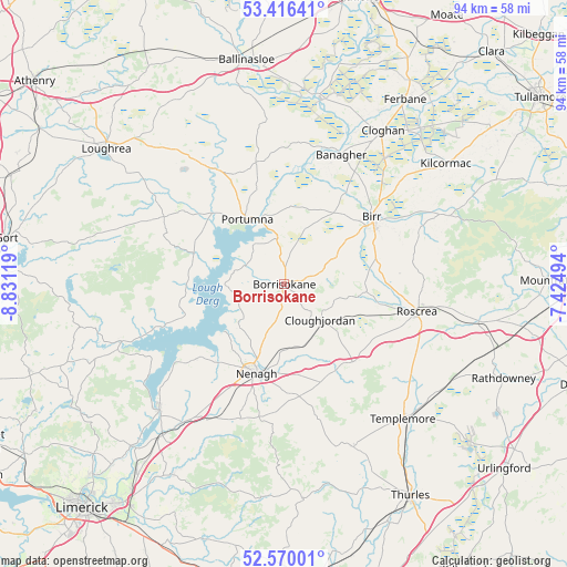
Borrisokane GPS coordinates[2]
52° 59' 43.008" North, 8° 7' 41.016" West
| Map corner | latitude | longitude |
|---|---|---|
| Upper-left | 53.41641°, | -8.83119° |
| Center: | 52.99528°, | -8.12806° |
| Lower-right: | 52.57001°, | -7.42494° |
| Map W x H: | 94.1×94.1 km | = 58.5×58.5mi |
| max Lat: | 55.25° ⇑61.3% North |
| Borrisokane: | 52.99528° |
| min Lat: | ⇓38.7% South 51.52487° |
| min Long | Borrisokane | max Long |
| -10.26889° | -8.12806° | -6.04944° |
| W 35.1%⇐ | ⇒64.9% E |
Elevation
Elevation of Borrisokane is 62 m = 203 ft, and this is 7.5 m = 25 ft above average elevation for this country.
| Max E: |
262 m = 860 ft | 37.4% |
| Borrisokane | 62 m 203 ft | |
| Avg. | 54.5 m = 179 ft | |
Min E: |
0 m = 0 ft | 62.6% |
See also: Ireland elevation on elevation.city.
Geographical zone
Borrisokane is located in North temperate zone (between Tropic of Cancer and the Arctic Circle). Distance of this North polar circle is 1508.7 km =937.5 mi to North.| Distance of | km | miles | from Borrisokane |
|---|---|---|---|
| North Pole | 4114.5 | 2556.6 | to North |
| Arctic Circle | 1508.7 | 937.5 | to North |
| Tropic Cancer | 3286.6 | 2042.2 | to South |
| Equator | 5892.5 | 3661.4 | to South |


Nearby cities:
15 places around Borrisokane: (largest is in red/bold)
• Ballina
29.3 km =18.2 mi,  224°
224°
• Banagher
23.5 km =14.6 mi,  23°
23°
• Birr
17.9 km =11.1 mi,  53°
53°
• Borrisoleigh
29.5 km =18.3 mi,  156°
156°
• Cloghan
30 km =18.6 mi,  32°
32°
• Cloughjordan
8.7 km =5.4 mi,  134°
134°
• Kilcormac
33.4 km =20.8 mi, 53°
• Killaloe
29.8 km =18.5 mi,  225°
225°
• Nenagh
15.5 km =9.6 mi,  197°
197°
• Nenagh Bridge
13.4 km =8.3 mi, 199°
• Portumna
12.1 km =7.5 mi,  329°
329°
• Roscrea
22.4 km =13.9 mi,  102°
102°
• Scarriff
28.8 km =17.9 mi,  250°
250°
• Shinrone
13.7 km =8.5 mi, 95°
• Templemore
29.8 km =18.5 mi,  138°
138°
Sources, notices
• [Note1] Compared only with cities in Ireland existing in our database
• [Src1] Map data: © OpenStreetMap contributors (CC-BY-SA)
• [Src2] Other city data from geonames.org with taken over terms of usage.
• [Src3] Geographical zone / Annual Mean Temperature by Robert A. Rohde @ Wikipedia
