Newcastle West geodata
Newcastle West (Munster) is a populated place; located in Ireland in Europe/Dublin (GMT+1) time zone. With population of 6,327 people, there are 110 cities with bigger population in this country. Compared to other cities in Ireland, 81.2% of cities are located further ↑North; 90.3% of cities are located further →East and 58.4% of cities have lower elevation than Newcastle West. Note1


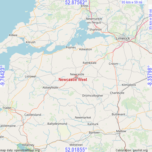
Newcastle West GPS coordinates[2]
52° 26' 57.012" North, 9° 3' 39.996" West
| Map corner | latitude | longitude |
|---|---|---|
| Upper-left | 52.87562°, | -9.76423° |
| Center: | 52.44917°, | -9.06111° |
| Lower-right: | 52.01855°, | -8.35798° |
| Map W x H: | 95.3×95.3 km | = 59.2×59.2mi |
| max Lat: | 55.25° ⇑81.2% North |
| Newcastle West: | 52.44917° |
| min Lat: | ⇓18.8% South 51.52487° |
| min Long | Newcastle West | max Long |
| -10.26889° | -9.06111° | -6.04944° |
| W 9.7%⇐ | ⇒90.3% E |
Elevation
Elevation of Newcastle West is 59 m = 194 ft, and this is 4.5 m = 15 ft above average elevation for this country.
| Max E: |
262 m = 860 ft | 41.6% |
| Newcastle West | 59 m 194 ft | |
| Avg. | 54.5 m = 179 ft | |
Min E: |
0 m = 0 ft | 58.4% |
See also: Ireland elevation on elevation.city.
Geographical zone
Newcastle West is located in North temperate zone (between Tropic of Cancer and the Arctic Circle). Distance of this North polar circle is 1569.4 km =975.2 mi to North.| Distance of | km | miles | from Newcastle West |
|---|---|---|---|
| North Pole | 4175.3 | 2594.4 | to North |
| Arctic Circle | 1569.4 | 975.2 | to North |
| Tropic Cancer | 3225.9 | 2004.5 | to South |
| Equator | 5831.8 | 3623.7 | to South |


Nearby cities:
15 places around Newcastle West: (largest is in red/bold)
• Abbeyfeale
18 km =11.2 mi,  245°
245°
• Adare
21.9 km =13.6 mi,  55°
55°
• Askeaton
17.7 km =11 mi,  19°
19°
• Ballingarry
13.6 km =8.5 mi,  78°
78°
• Bruree
27.1 km =16.8 mi,  96°
96°
• Croom
24.5 km =15.2 mi,  71°
71°
• Dromcollogher
16 km =9.9 mi,  139°
139°
• Foynes
18.3 km =11.4 mi,  349°
349°
• Glin
20.2 km =12.6 mi,  311°
311°
• Listowel
28.7 km =17.8 mi,  269°
269°
• Newmarket
26.2 km =16.3 mi,  170°
170°
• Pallaskenry
25.2 km =15.7 mi,  31°
31°
• Rathkeale
11.8 km =7.3 mi,  44°
44°
• Ráth Luirc
27.9 km =17.3 mi,  113°
113°
• Tarbert
25.3 km =15.7 mi,  302°
302°
Sources, notices
• [Note1] Compared only with cities in Ireland existing in our database
• [Src1] Map data: © OpenStreetMap contributors (CC-BY-SA)
• [Src2] Other city data from geonames.org with taken over terms of usage.
• [Src3] Geographical zone / Annual Mean Temperature by Robert A. Rohde @ Wikipedia
