Abbeyleix geodata
Abbeyleix (Leinster) is a populated place; located in Ireland in Europe/Dublin (GMT+1) time zone. With population of 1,827 people, there are 239 cities with bigger population in this country. Compared to other cities in Ireland, 64.1% of cities are located further ↑North; 50.9% of cities are located further ←West and 91.8% of cities have lower elevation than Abbeyleix. Note1


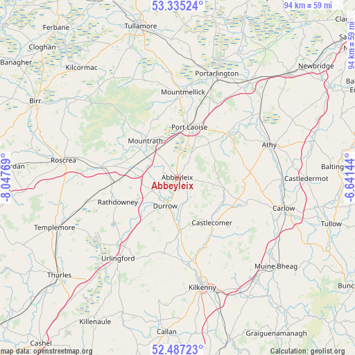
Abbeyleix GPS coordinates[2]
52° 54' 47.916" North, 7° 20' 40.416" West
| Map corner | latitude | longitude |
|---|---|---|
| Upper-left | 53.33524°, | -8.04769° |
| Center: | 52.91331°, | -7.34456° |
| Lower-right: | 52.48723°, | -6.64144° |
| Map W x H: | 94.3×94.3 km | = 58.6×58.6mi |
| max Lat: | 55.25° ⇑64.1% North |
| Abbeyleix: | 52.91331° |
| min Lat: | ⇓35.9% South 51.52487° |
| min Long | Abbeyleix | max Long |
| -10.26889° | -7.34456° | -6.04944° |
| W 50.9%⇐ | ⇒49.1% E |
Elevation
Elevation of Abbeyleix is 111 m = 364 ft, and this is 56.5 m = 185 ft above average elevation for this country.
| Max E: |
262 m = 860 ft | 8.2% |
| Abbeyleix | 111 m 364 ft | |
| Avg. | 54.5 m = 179 ft | |
Min E: |
0 m = 0 ft | 91.8% |
See also: Ireland elevation on elevation.city.
Geographical zone
Abbeyleix is located in North temperate zone (between Tropic of Cancer and the Arctic Circle). Distance of this North polar circle is 1517.8 km =943.1 mi to North.| Distance of | km | miles | from Abbeyleix |
|---|---|---|---|
| North Pole | 4123.7 | 2562.3 | to North |
| Arctic Circle | 1517.8 | 943.1 | to North |
| Tropic Cancer | 3277.5 | 2036.5 | to South |
| Equator | 5883.4 | 3655.8 | to South |


Nearby cities:
15 places around Abbeyleix: (largest is in red/bold)
• Athy
25.9 km =16.1 mi,  70°
70°
• Ballylinan
20.7 km =12.9 mi,  80°
80°
• Ballyragget
13.9 km =8.6 mi,  176°
176°
• Castlecomer
14.9 km =9.3 mi,  142°
142°
• Clonaslee
28.7 km =17.8 mi,  335°
335°
• Durrow
8.3 km =5.2 mi,  202°
202°
• Freshford
20.3 km =12.6 mi,  190°
190°
• Killenard
27.7 km =17.2 mi,  28°
28°
• Moneenroe
15.1 km =9.4 mi,  122°
122°
• Mountmellick
22.3 km =13.9 mi,  4°
4°
• Mountrath
12.8 km =8 mi,  317°
317°
• Portlaoise
13.8 km =8.6 mi,  12°
12°
• Rathdowney
17.1 km =10.6 mi,  247°
247°
• Stradbally
17.2 km =10.7 mi,  48°
48°
• Urlingford
26.7 km =16.6 mi,  216°
216°
Sources, notices
• [Note1] Compared only with cities in Ireland existing in our database
• [Src1] Map data: © OpenStreetMap contributors (CC-BY-SA)
• [Src2] Other city data from geonames.org with taken over terms of usage.
• [Src3] Geographical zone / Annual Mean Temperature by Robert A. Rohde @ Wikipedia
