Rathdowney geodata
Rathdowney (Leinster) is a populated place; located in Ireland in Europe/Dublin (GMT+0) time zone. With population of 1,208 people, there are 311 cities with bigger population in this country. Compared to other cities in Ireland, 65.8% of cities are located further ↑North; 53.5% of cities are located further →East and 88.6% of cities have lower elevation than Rathdowney. Note1


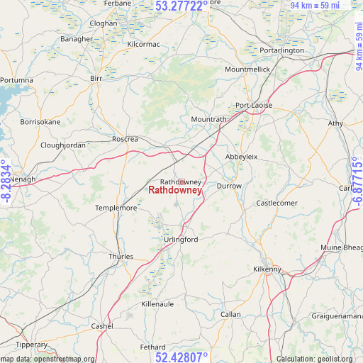
Rathdowney GPS coordinates[2]
52° 51' 16.992" North, 7° 34' 49.008" West
| Map corner | latitude | longitude |
|---|---|---|
| Upper-left | 53.27722°, | -8.2834° |
| Center: | 52.85472°, | -7.58028° |
| Lower-right: | 52.42807°, | -6.87715° |
| Map W x H: | 94.4×94.4 km | = 58.7×58.7mi |
| max Lat: | 55.25° ⇑65.8% North |
| Rathdowney: | 52.85472° |
| min Lat: | ⇓34.2% South 51.52487° |
| min Long | Rathdowney | max Long |
| -10.26889° | -7.58028° | -6.04944° |
| W 46.5%⇐ | ⇒53.5% E |
Elevation
Elevation of Rathdowney is 102 m = 335 ft, and this is 47.5 m = 156 ft above average elevation for this country.
| Max E: |
262 m = 860 ft | 11.4% |
| Rathdowney | 102 m 335 ft | |
| Avg. | 54.5 m = 179 ft | |
Min E: |
0 m = 0 ft | 88.6% |
See also: Ireland elevation on elevation.city.
Geographical zone
Rathdowney is located in North temperate zone (between Tropic of Cancer and the Arctic Circle). Distance of this North polar circle is 1524.3 km =947.2 mi to North.| Distance of | km | miles | from Rathdowney |
|---|---|---|---|
| North Pole | 4130.2 | 2566.4 | to North |
| Arctic Circle | 1524.3 | 947.2 | to North |
| Tropic Cancer | 3271 | 2032.5 | to South |
| Equator | 5876.9 | 3651.7 | to South |


Nearby cities:
15 places around Rathdowney: (largest is in red/bold)
• Abbeyleix
17.1 km =10.6 mi,  67°
67°
• Ballyragget
18.3 km =11.4 mi,  113°
113°
• Borrisoleigh
27.5 km =17.1 mi,  245°
245°
• Castlecomer
25.4 km =15.8 mi,  102°
102°
• Durrow
12.7 km =7.9 mi, 95°
• Freshford
18.1 km =11.2 mi,  137°
137°
• Moneenroe
28.6 km =17.8 mi,  93°
93°
• Mountrath
17.6 km =10.9 mi,  24°
24°
• Portlaoise
27.4 km =17 mi,  43°
43°
• Roscrea
18.3 km =11.4 mi,  305°
305°
• Shinrone
27.1 km =16.8 mi,  301°
301°
• Templemore
18.3 km =11.4 mi, 248°
• Thurles
24.3 km =15.1 mi,  217°
217°
• Twomileborris
22.4 km =13.9 mi,  204°
204°
• Urlingford
14.9 km =9.3 mi,  180°
180°
Sources, notices
• [Note1] Compared only with cities in Ireland existing in our database
• [Src1] Map data: © OpenStreetMap contributors (CC-BY-SA)
• [Src2] Other city data from geonames.org with taken over terms of usage.
• [Src3] Geographical zone / Annual Mean Temperature by Robert A. Rohde @ Wikipedia
